Subject: World
Period: 1720 (circa)
Publication: Atlas Coelestis
Color: Hand Color
Size:
22.6 x 18.9 inches
57.4 x 48 cm
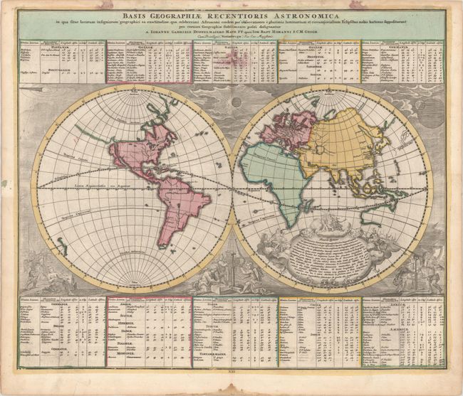
Dopplemayr's scarce world map is a unique combination of scientific and decorative cartography. The map is based on coordinates established for 138 places, which are shown in the tables above and below the double hemisphere map. The continents are shown in outline form without political detail. In North America California is an island, and there is a hint of a possible Northwest Passage from Hudson Bay to the Strait of Anian. In the Eastern Hemisphere only the western and northern coastlines of Australia are shown, and Japan appears twice (once to illustrate Sanson's error that placed it too far east). The richly engraved decorative elements are much more than mere embellishments. The scenes include cherubs using a variety of contemporary instruments at an observatory. On the left, a cherub is sighting a long refracting telescope on the lunar eclipse in the opposite upper corner. In the center, a solar projector is used to measure the eclipse of the sun in the spandrel directly above. On the right, longitude is being determined by observing the transit of the moons of Jupiter in the upper left corner. Shirley refers to this map as being 'neglected' and considers it "in advance of its time." It certainly is one of the most interesting world maps of the 18th century. This is the first state.
References: Shirley (TMC-46) pp. 34-38.
Condition: B+
Full contemporary color with some errant ink in the table at top center and in the top blank margin. There is light soiling and faint dampstains along the edges of the sheet.