Subject: Western Hemisphere - America
Period: 1740 (circa)
Publication:
Color: Hand Color
Size:
13.1 x 8.8 inches
33.3 x 22.4 cm
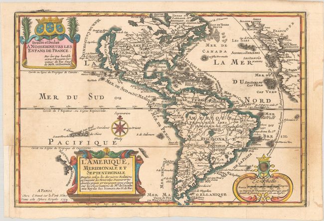
This charming map of the Americas is a reduced derivative of De Fer's classical wall map of 1698 with information gathered from the archives of the Academie Royale des Sciences. The island of California covers the entire west coast of North America north of the Tropic of Cancer with two large imaginary islands off shore. One of the prominent features in northern Mexico is Les Mine de S. Iean et de Ste. Barbe, the legendary Santa Barbara mines of the Chihuahua-Durango region. There are several large spurious lakes on both continents. A partial coastline of New Zealand appears beside the title cartouche. The map is richly decorated with three cartouches and a compass rose. This is the fourth state with the imprint of G. Danet at bottom left. On this example, a previous owner replaced in facsimile the original printed date of 1740 with the previous state's date of 1717.
References: Burden #759; McLaughlin #135; Tooley (Amer) #61, p. 126.
Condition: B+
A nice impression issued folding on watermarked paper with light soiling and a small hole in the imprint that has been repaired with archival materials on verso, with the date inaccurately replaced in facsimile. There is a binding trim in the bottom left margin that has been replaced with old paper, and a 1" associated tear has been closed on verso with archival materials.