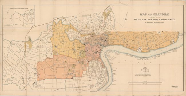
Subject: Shanghai, China
Period: 1918 (dated)
Publication: North-China Daily News & Herald
Color: Printed Color
Size:
58.3 x 28 inches
148.1 x 71.1 cm
This very rare map focuses on the Shanghai International Settlement and the French Concession and was published in one of the most influential foreign-language newspapers in China at the time. The Shanghai International Settlement was established in 1863 with the merging of the British and American enclaves in the city, which had originally been created as a result of the Qing Army's defeat by the British during the First Opium War. The Shanghai International Settlement remained under Chinese sovereignty, but was governed by the Shanghai Municipal Council, which was initially comprised of British and American nationals, although dominated by the British. The Municipal Council controlled nearly every facet of the settlement, including the police, utilities, road building and maintenance, taxation, regulations, and even the opium trade, which was finally banned the same year this map was published. Although the French Concession participated in the Municipal Council in the early years, it exited the Council in 1862 in order to preserve French independence.
The Municipal Council regularly published maps of the foreign enclaves, which were often republished by the North-China Daily News & Herald. This popular and influential English-language newspaper was founded as the North-China Herald in 1850 by British national Henry Shearman. The paper was expanded to a daily edition in 1864 and became the official publisher of notices from the British Superintendent of Trade and the Shanghai consulate.
The map gives excellent detail of roads, rivers, canals, and important sites and buildings throughout the area, including businesses, schools, wharves, police stations, public works, churches, clubs, hotels, markets, parks, and more. A few locations are also identified outside of the settlement, such as the Siccawei (Zikawei) Observatory, the Shanghai Jewish Club, and a refuge for Chinese slave children. The Shanghai International Settlement is divided into four districts (central, northern, eastern and western) and the size of each district, as well as the French Concession, is listed in a table at right. The imprint of Waterlow & Sons Limited in London appears below the map at center.
References:
Condition: B+
A bright example, issued folding and now flattened and professionally backed in archival tissue to repair some separations and small holes along the folds. There are a few spots of soiling and some interesting contemporary pencil notations from a previous owner, including "Japs in charge - Hongkew" (Hongkou) in the Northern District and several directional notes.