Subject: Eastern Mediterranean & Middle East
Period: 1579 (published)
Publication: Le Miroir du Monde
Color: Hand Color
Size:
4.2 x 3.1 inches
10.7 x 7.9 cm
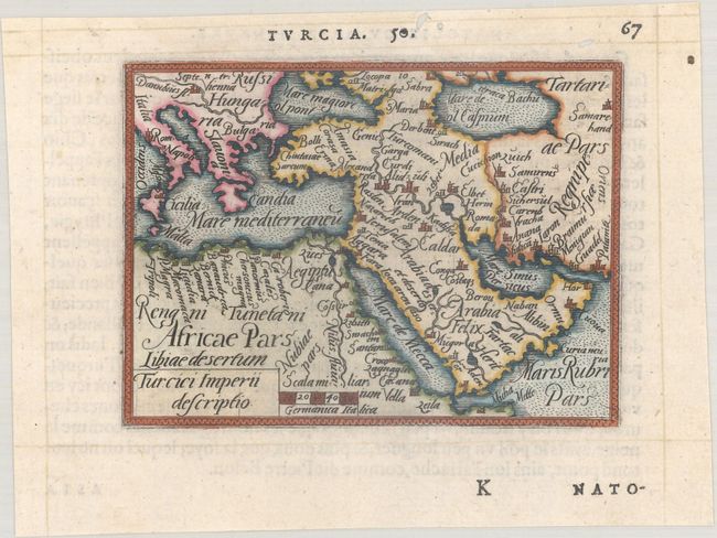
Beautifully and fully engraved copperplate map of the Arabian peninsula and Turkey. The map extends to show southern Europe naming Hungary, most of the Mediterranean to Italy and Crete, the Caspian and Black seas, and Tartary. The shape of Arabia is very rudimentary, and although some towns are named, Mecca and Medina are not shown. French text on verso.
This map is from the first pocket-sized atlas, Spieghel der Wereld, which was based on Ortelius' Theatrum Orbis Terrarum. The maps were engraved on copper by Filips Galle and represented all regions around the world. The maps were accompanied by text prepared by Peter Heyns, who used the text from the Theatrum. The numbers printed above the maps, adjacent to the letterpress title, indicate the number of the map within the Theatrum. This innovative, small atlas was designed to reach the lower middle class, and was a commercial success, prompting numerous reprints and imitations. The first edition of the Spieghel der Wereld was published in 1577, with subsequent editions published in French in 1579 and 1583, Dutch in 1583 and 1596, and Latin in 1585. One unique feature of this pocket atlas was the inclusion of 6 larger, fold-out maps of the world, Europe, France, Germania, the Low Countries and Italy that were included alongside 66 miniature maps.
References: King (2nd Ed.) pp. 64-65 & 88-89; Tibbetts #37; Van der Krogt (Vol. III) #8100:331.
Condition: A
A nice impression with small worm holes confined to the blank margins.