Subject: Canterbury, England
Period: 1599 (circa)
Publication: Civitates Orbis Terrarum, Vol. IV
Color: Hand Color
Size:
16.9 x 11.4 inches
42.9 x 29 cm
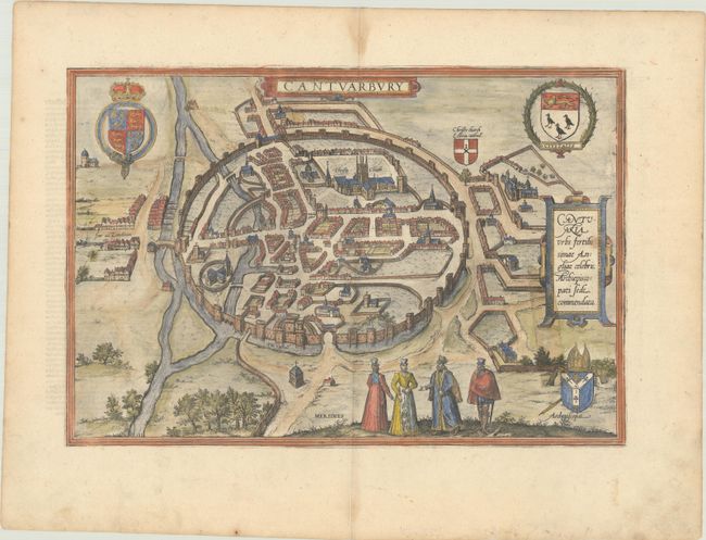
Braun & Hogenberg's Civitates Orbis Terrarum or "Cities of the World" was published between 1572 and 1617. Within the six volumes, 531 towns and cities were depicted on 363 plates, providing the reader with the pleasures of travel without the attendant discomforts. Braun wrote in the preface to the third book, "What could be more pleasant than, in one's own home far from all danger, to gaze in these books at the universal form of the earth . . . adorned with the splendor of cities and fortresses and, by looking at pictures and reading the texts accompanying them, to acquire knowledge which could scarcely be had but by long and difficult journeys?" Braun and Hogenberg incorporated an astonishing wealth of information into each scene beyond the city layout and important buildings. The plates provide an impression of the economy and prominent occupations, and illustrate local costumes, manners and customs.
Beautiful bird's-eye view of Canterbury. The famous cathedral is the most prominent feature, shown enclosed within the ancient city walls. The city is fully fortified by a massive mortar wall with seven entrances, two ducts for the river and thirty-seven towers, and further protected by a moat surrounding the southern half of the city. Locates the Castle and shows the road to London. The map is richly adorned with the coats of arms of England, Canterbury and the Archbishop. German text on verso.
References: Fussel, p. 270.
Condition: B
There is a spot in the cartouche at right and show-through of a strip of non-archival tape that was placed on the verso of the map adjacent to that same cartouche.