Subject: North Atlantic
Period: 1804 (dated)
Publication: The Naval Chronicle for 1804...
Color: Black & White
Size:
15.4 x 6.1 inches
39.1 x 15.5 cm
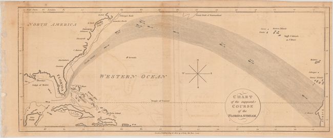
This simple chart depicts the Gulf Stream from the Strait of Florida to C. Blanco along the coast of Africa. Directional arrows are shown within the Gulf Stream. The track of a ship is shown beginning in New Providence Island and extending north along the coast of the United States. This map was published in The Naval Chronicle opposite a letter to the editor dated Jan. 23, 1804 and signed by "A.Z." The author of this letter gives an account of his "passage from New Providence to Nova Scotia, in the Summer of 1798" with details of the differences in air temperature and wind direction observed during his trip. He also explains that the accompanying chart was based on Governor Pownall's chart of the Gulf Stream.
The Naval Chronicle was published in London in six installments per year, bound in two volumes per year between 1799 and 1818, comprising 40 volumes. More than 1,000 pages of British naval news and views were published every year in the Chronicle, including action reports, intelligence of foreign naval matters, and biographies of officers. it is a key source of British maritime and military history.
References: Jolly #NAV-8.
Condition: B
Issued folding on watermarked paper with light toning, minor offsetting, and a few spots of foxing at top.