Subject: Yellowstone, Wyoming
Period: 1903 (published)
Publication:
Color: Printed Color
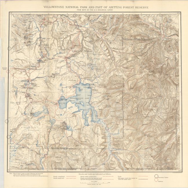
A. Yellowstone National Park and Part of Abutting Forest Reserve from Maps by the U.S. Geological Survey, (19.9 x 17.9"). This beautifully-colored topographical map was issued by the Park Superintendent after maps by the U.S. Geological Survey. It shows the entire park in great detail at a scale of four miles per inch. Legend identifies ranger stations, snowshoe cabins, existing roads, unused roads, trails and more. It locates the remote Shoshone, Lewis and Heart Lakes; names the Upper, Shoshone, Gibbon, and Heart Lake Geyser Basins, Mud Geysers, Mammoth Hot Springs and more. There is terrific detail of topography with contour intervals at 100 feet, watershed and numerous features.
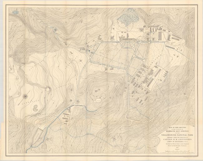
B. Map of the Grounds in the Vicinity of Mammoth Hot Springs in the Yellowstone National Park Prepared Under the Direction of Captain H.M. Chittenden Corps of Engineers, U.S.A., (42.0 x 33.3"). This fabulous large-scale map is focused on the Mammoth Hot Springs area. The details, drawn on a scale of 100 feet per inch, is exceptional including contour lines every five feet (!). Locates the buildings around the main hotel including the Cottage Hotel, numerous support buildings, U.S. Commissioner's residence, roads, living quarters and much more. This map extends to also locate the Electric Light Power House, Ice Houses, the Old Quartermaster's Department buildings, McCartney's Log House, and the Flume & Aqueduct. The map is completed by an attractive compass rose and fleur-de-lis not typically seen on government maps.
The folding maps are accompanied by the Superintendent's 15-page report.
References:
Condition: A
The maps are clean and bright, issued folding. Disbound text has a hint of pleasant light toning.