Subject: Texas, Gulf Coast
Period: 1851-73 (dated)
Publication:
Color: Black & White
The Office of Coast Survey is the oldest U.S. scientific organization, dating from 1807 when Congress directed that a "survey of the coast" be carried out. By 1836, it was called the U.S. Coast Survey and in 1878, the name was changed to the U.S. Coast and Geodetic Survey. Today the Office of Coast Survey is a division of the National Oceanic and Atmospheric Administration NOAA.
The survey teams, composed of civilians as well as Army and Naval officers, charted the nation's waterways and produced a wide array of reports, survey charts, hydrographic studies of tides and currents, astronomical studies and observations, and coastal pilots. These charts are an important record of the changing nature of the nation's coastlines. In additional to coastal charts, the U.S. Coast and Geodetic Survey produced land sketches, Civil War battle maps, and the early aeronautical charts.
Ten early Coast Survey charts showing the development of the Texas Gulf Coast in the latter part of the 19th century:
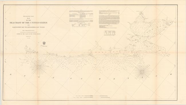
A. Preliminary Chart No. 31 of the Sea Coast of the Untied States from Galveston Bay to Matagorda Bay Texas..., dated 1857 (36.4 x 20.2"). A detailed chart of the region including numerous soundings, bottom types, magnetic variation, and detailed navigational notes. Condition: Clean and bright with a hint of toning along a few folds. (A)
B. Preliminary Chart of the Entrance to Matagorda Bay Texas from a Trigonometrical Survey..., dated 1857 (32.4 x 19.4"). Three charts on one sheet. The primary chart features numerous soundings in Matagorda Bay with good coastal detail of Matagorda Island and Matagorda Peninsula. The other two charts depict Lavaca, Chocolate, and Matagorda bays. Condition: There is light toning along the folds with several fold separations and a 4" tear at lower left. (B)
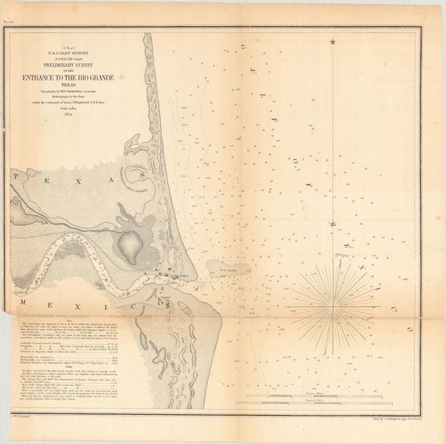
C. Preliminary Survey of the Entrance to the Rio Grande Texas, dated 1854 (14.6 x 13.6"). This represents the only U.S.C.S. charting of the area. It provides a detailed view of the first few miles of this great river. At the mouth of the river is the village of Bagdad, and an observatory is located on the opposite shore. There is nice topographical detail and many soundings given, including in the Rio Grande itself. Condition: There are several fold separations that have been repaired with a combination of both archival and non-archival tape. Trimmed to inside the neatline at lower left. (B)
D. Preliminary Chart of Entrance to Brazos River Texas, dated 1858 (17.8 x 15.6"). Shows the path of the Brazos River to the Gulf of Mexico with the towns of Quintana and Velasco flanking its mouth. Condition: There is light toning and offsetting with a 10" fold separation. Binding trim at lower left. (B)
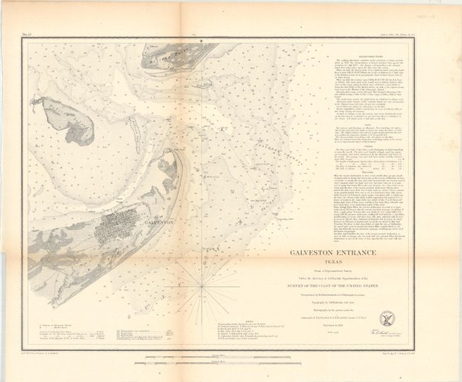
E. Galveston Entrance Texas from a Trigonometrical Survey..., dated 1856 (17.2 x 13.7"). This coastal survey chart details the entrance to Galveston Bay, including the street grid of Galveston. The chart extends to Pelican Island, Bird Key, and Bolivar Point. It locates buoys, a beacon, a light boat, and is filled with soundings, bottom types and extensive notations on sailing directions. Condition: Light toning along the fold lines. (B+)
F. Preliminary Sketch of Galveston Bay Indicating Proposed Sites for Light Houses..., dated 1851 (16.8 x 19.5"). This handsome coastal chart shows the entire Galveston Bay with the city located at its entrance on Galveston Island. Includes insets of Clopper's Bar and Red Fish Bar. Condition: There is light toning along the horizontal fold and a short edge tear at left. (B+)
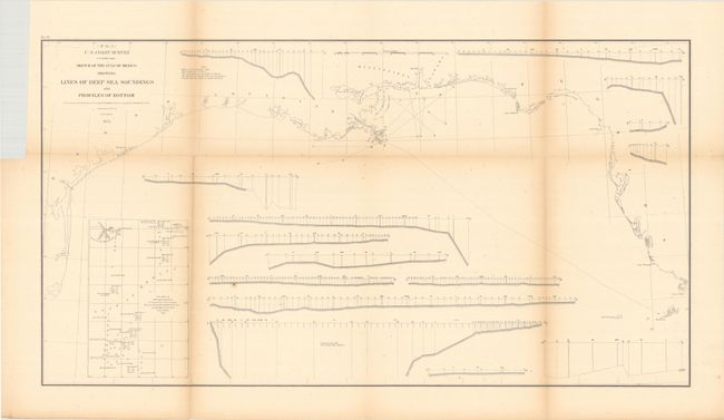
G. Sketch of the Gulf of Mexico Showing Lines of Deep Sea Soundings and Profiles of Bottom, dated 1855 (27.9 x 14.9"). An interesting sheet showing a chart of the Gulf Coast with 15 different profiles showing the various depths of the Gulf's bottom. Condition: Light toning along the fold lines. (B+)
H. Sketch I Showing the Progress of the Survey in Section No. 9 1848 to 51, circa 1851 (12.6 x 7.5"). Presents the surveying progress along the coast from Corpus Christi to Galveston. Condition: Light toning along the fold. (B+)
I. Sketch I Showing the Progress of the Survey in Section No. IX from 1848 to 1871, dated 1873 (22.6 x 17.6"). Shows the triangulations in the vicinity of Galveston Bay. Condition: Light dampstains along the left fold. (B+)
J. Sketch I No. 3 Aransas Pass Coast of Texas..., dated 1851 (8.0 x 7.4"). Covers San Jose Island, Mustang Island and Aransas Pass. Condition: A hint of toning, otherwise fine. (A)
References:
Condition:
See description above. Issued folding.