Catalog Archive
Auction 184, Lot 274

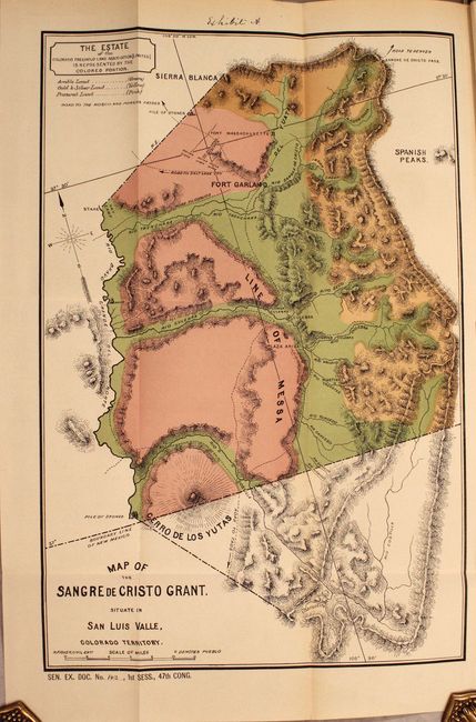
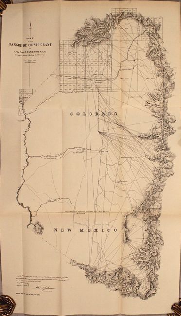
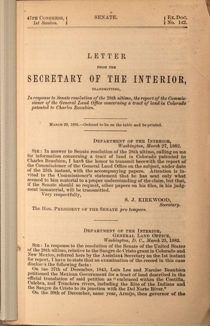
"[Map in Report] Map of the Sangre de Cristo Grant. Situate in San Luis Valle, Colorado Territory [in] Letter from the Secretary of the Interior ... the Report of the Commissioner of the General Land Office Concerning a Tract of Land in Colorado...", General Land Office

Subject: Colorado

Period: 1882 (published)

Publication: Sen. Ex. Doc. No. 142, 47th Congress, 1st Session

Color: Printed Color

Size:
11.7 x 17.5 inches
29.7 x 44.5 cm
Download High Resolution Image
(or just click on image to launch the Zoom viewer)

This 64-page report concerns the Sangre de Cristo land grant patented by Charles Beaubien and includes five folding maps of the region. Of particular interest are the following:

A. Map of the Sangre de Cristo Grant. Situate in San Luis Valle, Colorado Territory, hand color (11.7 x 17.4"). The estate of the Colorado Freehold land is represented by the colored portion above the New Mexico border. Identifies arable land (green), gold and silver land (tan though it states yellow) and pasture land (pink). Locates roads, rivers and Fort Massachusetts. Topography is nicely developed.

B. Map of the Sangre de Cristo Grant in Colorado & New Mexico Surveyed by Edwin H. Kellogg Dep. U.S. Surveyor, black & white (13.2 x 22.6"). A triangulation map by E.H. Kellogg showing the public land grid, Fort Garland, settlements, surveying points, Rio Grande del Norte and other rivers, creeks, mountain peaks and roads.

For an interesting article on Beaubien and his land grants, click here. A rarely offered report detailing Colorado's first land grant. Disbound in plastic report covers.

References:

Condition: B+

Maps have pleasant light toning and a few tiny splits at the fold junctions. Text is also lightly toned. Disbound report is housed in plastic covers.

Estimate: $160 - $190

Sold for: $220

Closed on 9/15/2021

Archived