Catalog Archive
Auction 184, Lot 242

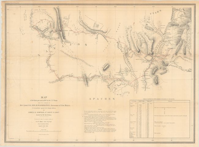
"Map of the Route Pursued in 1849 by the U.S. Troops, Under the Command of Bvt. Lieut. Col. Jno. M. Washington, Governor of New Mexico, in an Expedition Against the Navajos Indians", Simpson/Kern

Subject: Southwestern United States

Period: 1849 (dated)

Publication: Reports of Secretary of War - Report of Lieut. J. H. Simpson of an Expedition into the Navajo Country

Color: Hand Color

Size:
27.6 x 20.3 inches
70.1 x 51.6 cm
Download High Resolution Image
(or just click on image to launch the Zoom viewer)

This important map led to the opening up of the region to travel and settlement. It was the product of a punitive expedition against marauding Navajo Indians. The expedition traveled from Santa Fe to Jemez Pueblo, then on the Navaho trail to Chaco Canyon, and via Washington Pass to Canyon de Chelly. They engaged the Navajo in their strongholds at Chaco Canyon and Canyon de Chelly where the tribe was soundly defeated. The soldiers then explored the area and were the first white men to discover and describe the prehistoric pueblos in the region. The return route traveled south of the Zuni Pueblos and east past Inscription Rock and Laguna Pueblo to the Rio Grande. A seldom seen map that Wheat calls "an arresting production, bringing out many new details of the region."

References: Wheat (TMW) #641.

Condition: B+

Issued folding with some light extraneous creasing at left and a few spots of foxing. A 2.5" edge tear at left has been closed on verso with archival tape.

Estimate: $450 - $550

Sold for: $400

Closed on 9/15/2021

Archived