Subject: World
Period: 1553 (circa)
Publication: Cosmographia Petri Apiani…
Color: Black & White
Size:
10.9 x 7.4 inches
27.7 x 18.8 cm
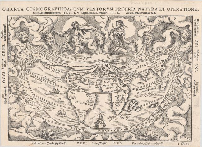
This early map is based on the now lost world map of Gemma Frisius [1540], which is significant in the history of the mapping of America. The continents are broadly based on Mercator's globe gores of 1541, but North America is shown as a long slender landmass labeled Baccalearium in reference to the cod fishing region off the coasts of New England and Canada. It employs a cordiform projection and depicts a distinct northern passage to Asia over the top of North America. There are few geographical features other than the prominent twin lake sources of the Nile in Africa. The heart-shaped border of the map contains signs of the zodiac within a cloud background filled with mythical figures and wind heads. One of the deities at top sports the design of the Holy Roman Emperor's double eagle on his breastplate and the three cadaverous wind heads at bottom represent plague-carrying winds of the south. This is an example from the second of three woodblocks, issued with Latin and Dutch text. This is an original published circa 1564 - it differs from the counterfeit map mentioned by Shirley, in that there is no evidence of a crack in the plate at top and the paper is not watermarked.
References: Shirley #96.
Condition: A
A dark impression on a bright sheet with a few minor ink and pen notations in the blank margins. The edges at left, right and bottom are trimmed but ample for framing. Issued folding, now flattened, with a small binding trim at bottom left that has been professionally replaced with leafcasting.