Subject: Texas
Period: 1858 (circa)
Publication: General Atlas
Color: Hand Color
Size:
26.3 x 17 inches
66.8 x 43.2 cm
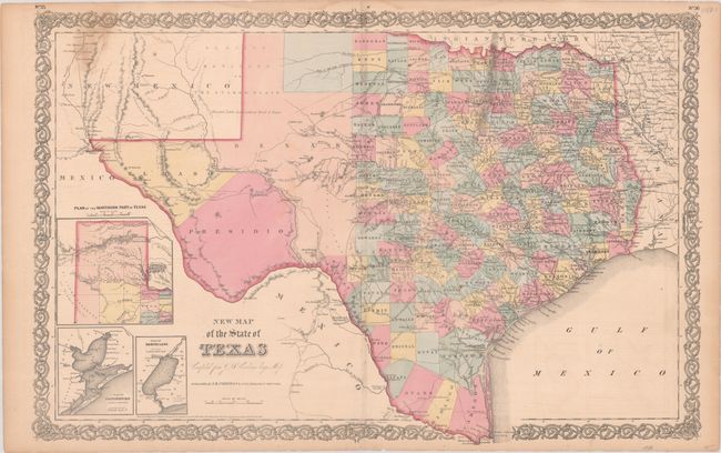
This handsome Texas map is based on an important 1849 map by Jacob de Cordova, which was the first to be drawn from General Land Office records. It shows extensive detail throughout the settled part of the state. The western third is comprised of the large unsettled areas of Presidio, El Paso, Bexar and El Llano Estacado or the Staked Plain. Unlike earlier editions of this map, Cooke County is not identified in the northern part of the state. The other county development is consistent with circa 1858, with the inclusion of new counties such as Zavala, Bee, and Montague. Railroads, forts, post offices, roads, springs, and topographical detail are all clearly indicated. Three insets show the panhandle, Galveston Bay, and Sabine Lake. The copyright date is somewhat indistinct, but it reads either 1855 or 1856.
References:
Condition: B
Contemporary color with light soiling and faint offsetting. There are short centerfold separations at top and bottom, the latter of which has been closed on verso with tape. Light dampstains run along the top edge of the sheet.