Subject: Michigan, Great Lakes, & Ontario
Period: 1825 (dated)
Publication: Atlas Universel de Geographie...
Color: Hand Color
Size:
20.2 x 18.1 inches
51.3 x 46 cm
Vandermaelen was the son of a wealthy industrialist who abandoned his father's business to follow a career in cartography. His goal was to produce the first atlas ever published in which every map was drawn on the same projection and to the same scale (1: 1,641,836), with each map covering an area of approximately 20 degrees of longitude (from Paris) and 6 degrees of latitude. Because of the consistent scale and projection, the maps could be joined together to form a huge globe that would measure over 25 feet in diameter. Vandermaelen had the only known globe constructed from his maps, requiring a special room for its display. It was also the first lithographic atlas ever published. There was one edition of the atlas, published in 1825-27, and the subscription list shows that only 810 copies were sold. Koeman called his Atlas Universel, "One of the most remarkable world atlases ever made. Far ahead of its time."
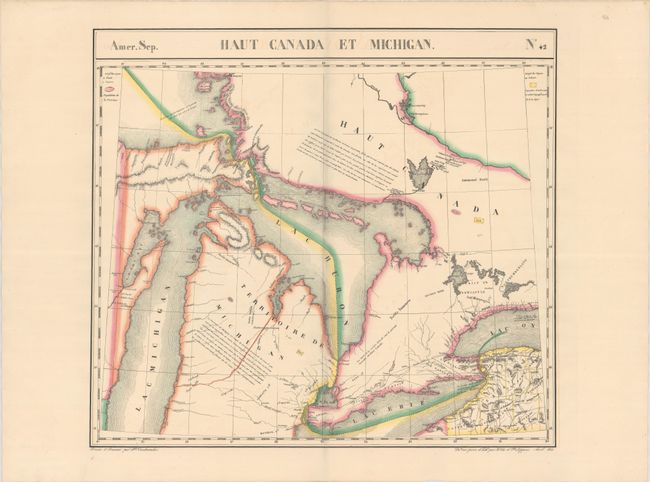
This handsome and informative map centers on Lake Huron. It also includes parts of the lakes Superior, Michigan, Erie, and Ontario. Michigan Territory is identified and divided by the Indian Line. South of the line, Oakland, Wayne, Monroe, and McComb counties are named, but not delineated. Detroit and a scattering of other settlements are named within the territory. The map provides plenty of information with population and area figures for the provinces and extensive notes in French text on the landscape. Much of Upper Canada is blank except for some settlement along the coasts of Lake Erie and Lake Ontario. A note in Upper Canada refers to the Detroit River as an earthly paradise. A portion of Western New York is shown with counties delineated. Drawn and lithographed by H. Ode et Ph. Lippens.
The Atlas Universel was the first atlas to present all the maps on the same scale (1: 1,641,836) about one inch to 26 miles, with each map covering an area of approximately 10 degrees longitude (from Paris) and 6 degrees of latitude. It was also considered to be the first lithographic atlas ever published. The maps were meant to be joined together to form a huge globe measuring 7.775 meters in diameter. Only one edition of the atlas was published in 1825-27, and the subscription list shows that just 810 copies were sold; thus the maps are very scarce on the market today.
See lot 574 for Louis Karpinski's Maps of Famous Cartographers Depicting North America - An Historical Atlas of the Great Lakes and Michigan that discusses this map.
References: Karpinski pp. 240 & 243.
Condition: A
Contemporary outline color with minor offsetting and a touch of soiling along the centerfold.