Subject: Minnesota & Dakotas
Period: 1855-64 (dated)
Publication:
Color: Hand Color
A nice pair of Colton maps showing the remarkable development in the region over a nine year period:
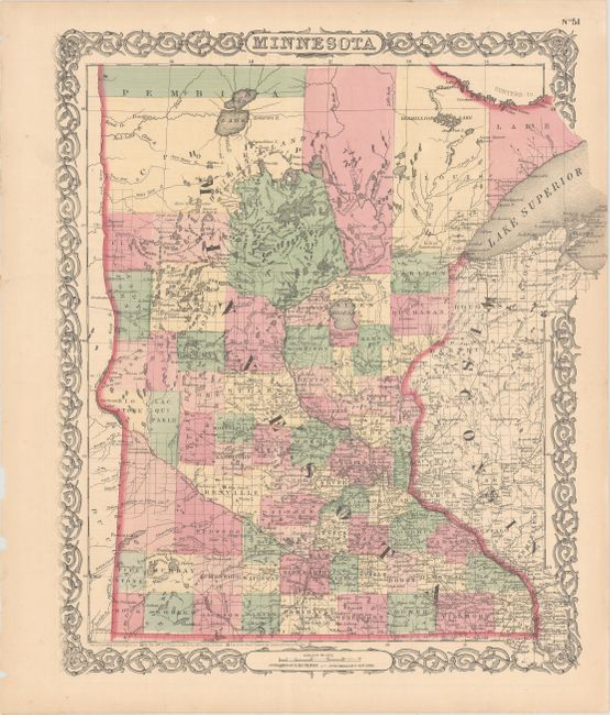
A. Minnesota, dated 1855 (16.2 x 12.8"). This very handsome map depicts Minnesota in a transitional configuration. Western Minnesota is soon to become Dakota Territory, but here it is merged with Minnesota and simply called Pembina. This huge unorganized area occupies a good deal of today's Minnesota in the west and north. Early county development in Minnesota shows little sign of railroads yet. An interesting notation locates vast prairies said to be "the great Hunting and Fighting Ground of Dakotah, Odjebwe, Assiniboin, Arikara, Minitarree and other Nations." The map is filled with details of forts, towns, watershed, lakes, and more. It is surrounded by Colton's signature strapwork border. Blank verso, published in 1855-1856.
B. Minnesota, dated 1864 (13.5 x 15.8"). A densely engraved map of the state with its present-day boundaries. Locates settlements, rivers, lakes, mountain ranges, and railroad lines. Development is limited to the lower half of the state and the area around the Duluth area. A network of railroads and roads fill the lower half with one running diagonally to Breckenridge and continuing westward across the North Red River or the Sioux Wood River. Another extends to Duluth. This edition is surrounded by Colton's familiar scroll-work decorative borders with oval cartouches incorporated at top and bottom for the title and publishers imprint.
References:
Condition: A
Nice examples with light toning along the sheet edges and a few minor edge chips confined to the far blank margins.