Subject: Ukraine, Russia & Black Sea
Period: 1716 (circa)
Publication: Atlas Novus
Color: Hand Color
Size:
19 x 22.8 inches
48.3 x 57.9 cm
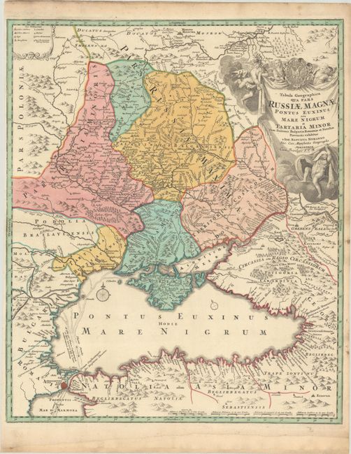
This superb map of the region bordering the Black Sea depicts present-day Ukraine and extends to include Constantinople in the south and north to Moscow and Smolensko. Great detail throughout shows mountains, watershed, roads, villages, towns, and battlefields. Within the Black Sea is an interesting notation and depiction of the Fluenta Danubii showing the waters of the Danube and the Dnieper Rivers flowing through the sea, into the Bosphorus, and out into the Mediterranean. The large decorative title cartouche is enveloped in clouds with several putti and the Russian coat of arms. The map is an updated, reissue of a map made by Major General George Mengden and Earl Yakov Bruce based on Russian Army routes during the Azov campaign of Peter I in 1695-96. The plate went through several revisions with this version removing the portrait and dedication to Peter I and adding the newly built Volga-Don canal (Canalis Perevoloc) just below the cartouche. This is the first state of the Homann edition (after 1715 his privilege was added to the cartouche).
References: Vavrychyn, Dashkevych & Kryshtalovych, Vol. II, p.132-33.
Condition: A
A nice impression on a watermarked sheet with a narrow but adequate left side margin. The bottom margin has been extended with old paper.