Subject: Ireland
Period: 1657 (circa)
Publication: Atlas Nuevo de los Reynos de Escosia e Yrlanda
Color: Hand Color
Size:
19.8 x 15.1 inches
50.3 x 38.4 cm
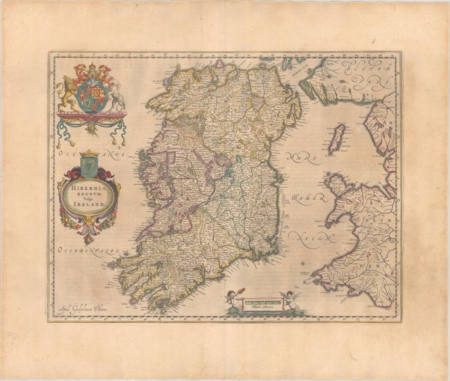
One of the most beautiful maps of Ireland, this was based on Speed's map and is geographically nearly identical. The map has finely engraved detail of the provinces of Leinster, Ulster, Connaght and Munster filled with counties, towns and charming pictorial topography. The upper and lower portions of Lough Erne in Ulster are oddly shaped, with a note between them relating, "At this place ly the landes, of O Darra, O Harna, O Harra Boy, O Harra Neirogh, the 2 McDonnoghes with other Erecholders." The map is adorned with the crest of Britain, and below that, the cartouche is topped with the crest of Ireland; the scale of miles is supported by two aquatic putti. Spanish text on verso, published between 1654-62.
Publication of Bleau’s atlas of Scotland and Ireland (Atlas Novus, Volume V) in 1654 was a landmark publication in cartographic history. Most of the maps were based on the surveys of Timothy Pont, which had been done half a century earlier. The publication took over seven decades to bring to publication; it was delayed by wars, copyright restrictions, and only intermittent official support. The maps are scarce today due to the relatively short publication history of the atlas.
References: Van der Krogt (Vol. I) #5900:2.
Condition: B+
A crisp impression with full contemporary color on a lightly toned sheet with a large Atlas watermark, marginal soiling, and a short edge tear at bottom that has been closed on verso with archival tape.