Subject: South America
Period: 1850 (circa)
Publication: Illustrated Atlas and Modern History of the World
Color: Hand Color
The maps from The Illustrated Atlas were first published in serial form to a target audience that led insular lives due to the expense and hardship of travel. All that changed as the progress of the nineteenth century brought swift and dramatic changes in public awareness of far away places. Tallis' maps no doubt played an important role in this dramatic awakening. These maps not only provided up-to-date geographical knowledge, but also used vignette views within the map's design to show the native people and their occupations, cities and points of interest. The maps hark back to a cartographic tradition from the Dutch mapmakers of the seventeenth century with finely engraved decorative borders. The maps were drawn and engraved by John Rapkin with views drawn and engraved by a number of prominent artists. The maps were issued as a complete volume from 1851 until about 1865. Some of the maps were also published in other history books published by Tallis including British Colonies and, without the vignettes, in geographical dictionaries and encyclopedias until about 1880.
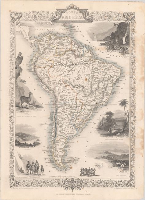
A. South America, (9.3 x 14.0"). This is a very lovely and well-engraved map of South America. It is filled with detail, including rivers, lakes, towns, and villages, and many place names along the coast. The continent is surrounded by eight vignettes and a decorative border and title cartouche. The vignettes show gold mining in Brazil, a Brazilian rope bridge, condors and llamas of Peru, natives of Chili, Valparaiso, figures descending the Cordilleras, natives transporting a barrel, and a view of Rio de Janeiro. John Rapkin drew and engraved the map. The vignettes were illustrated by J. Marchant and engraved by J. Rogers. Condition: Contemporary outline color with light scattered foxing and light stains at right.
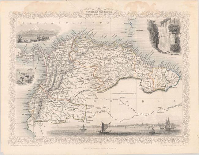
B. Venezuela, New Granada, Equador, and the Guayanas, (13.0 x 9.8"). This beautiful and finely engraved steel plate map of northern South America is decorated with vignettes including a panorama of Paramaribo from the sea, a waterfall of the Bagota River, ostriches, and Chimborazo. The map is drawn and engraved by John Rapkin, and the illustrations are drawn by H. Winkles and engraved by W. Lacey. Condition: Contemporary outline color with light stains that are mostly confined to the top margin and centerfold separations at top and bottom that have been closed on verso with tape.
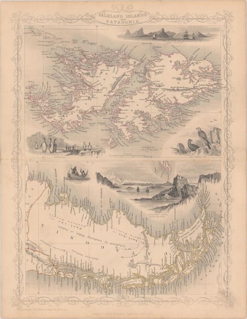
C. Falkland Islands and Patagonia, (10.0 x 13.5"). Two maps within one decorative border. The map of the Falklands is very detailed and is surrounded by finely rendered engravings of penguins, sea birds, and tall ships anchored off Jason Island. The map of Patagonia has good detail along the coastline, but little in the interior. It has a large vignette of Christmas Sound in Tierra del Fuego with clippers under sail plus a small vignette of Fugeans in a boat. Illustrations by H. Winkles and engraved by W. Lacey, maps drawn and engraved by J. Rapkin. Condition: Contemporary outline color on a lightly toned sheet with minor soiling.
References:
Condition: B+
See description above.