Catalog Archive
Auction 182, Lot 310
"[Lot of 4] Map of Oregon Territory West of the Cascade Mountains [and] Map of Oregon Territory West of the Cascade Mountains [and] A Diagram of Oregon [and] State of Oregon", General Land Office
Subject: Oregon
Period: 1855-76 (dated)
Publication:
Color: Black & White
Size:
See Description
Download High Resolution Image
(or just click on image to launch the Zoom viewer)
(or just click on image to launch the Zoom viewer)
This lot features four early General Land Office maps of Oregon:
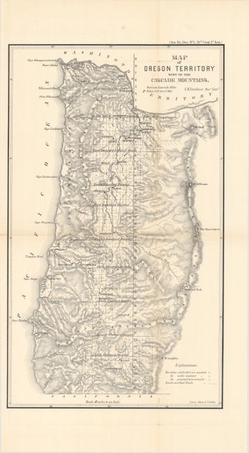
A. Map of Oregon Territory West of the Cascade Mountains, by C.K. Gardiner, from Sen. Ex. Doc. 1, 34th Congress, 1st Session dated 1855 (10.6 x 17.8"). An attractive and detailed map showing the extent of surveying within the territory. Locates two emigrant roads crossing the Cascades including one south of Mt. Hoad and the other just above Diamond Peak. Lithographed by A. Hoen & Co. in Baltimore. Condition: Clean and bright. (A)
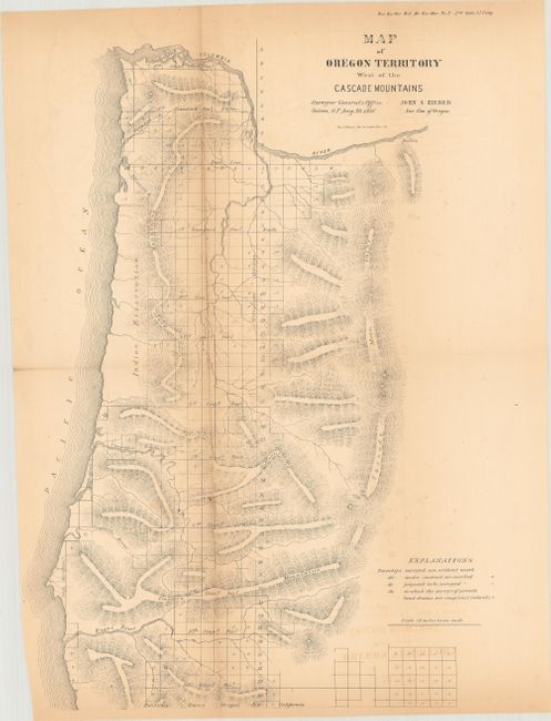
B. Map of Oregon Territory West of the Cascade Mountains, by John S. Zieber, from Sen. Ex. Doc. 1, 35th Congress, 2nd Session, dated 1858 (11.5 x 16.3"). This is an updated version of the map above and the last survey map of Oregon Territory. Condition: Light toning with a long fold separation closed on verso with archival tape. (B)
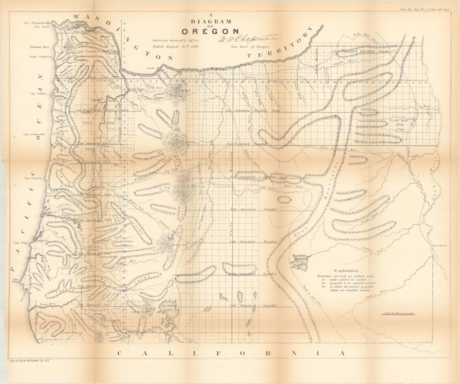
C. A Diagram of Oregon, by W.W. Chapman, from Sen. Ex. Doc. 2, 35th Congress, 1st Session dated 1859 (22.1 x 17.4"). This detailed map of the state shows topographical information in hachure, watersheds, and the progress of surveying. Eugene City, Oregon City, Port Orford, Roseburg, and many more are located. Trails and roads shown include the Trail to Powder River, Wallen's Route, Mix's Trail, and Road to Salt Lake. Just across the Snake River is Fort Boisee. Published in August 1859, less than six months after Oregon obtained statehood. Condition: Light toning along the folds with several small fold separations that have been partially closed on verso with archival tape. (B)
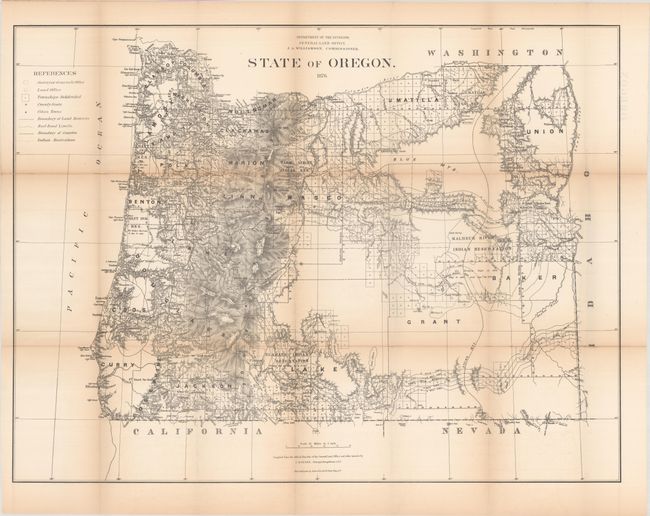
D. State of Oregon, by C. Roeser, dated 1876 (31.5 x 23.8"). This map was produced by the General Land Office as part of a series of maps of the states and territories to celebrate the Centennial. At the time they were recognized as the most accurate and detailed maps to date and were widely used by commercial mapmakers. The map provides excellent detail from the Cascade Mountains west to the coast, including all towns and villages, roads, and railroads. Topography is shown in bold hachure, and the granted and indemnity limits of military wagon roads are illustrated. The legend identifies Indian reservations, railroad limits and townships subdivided. Condition: Light toning along the fold lines with several fold separations that have been partially closed on verso with archival tape. (B)
D. State of Oregon, by C. Roeser, dated 1876 (31.5 x 23.8"). This map was produced by the General Land Office as part of a series of maps of the states and territories to celebrate the Centennial. At the time they were recognized as the most accurate and detailed maps to date and were widely used by commercial mapmakers. The map provides excellent detail from the Cascade Mountains west to the coast, including all towns and villages, roads, and railroads. Topography is shown in bold hachure, and the granted and indemnity limits of military wagon roads are illustrated. The legend identifies Indian reservations, railroad limits and townships subdivided. Condition: Light toning along the fold lines with several fold separations that have been partially closed on verso with archival tape. (B)