Subject: Alaska
Period: 1934 (dated)
Publication:
Color: Printed Color
Size:
28.3 x 21.1 inches
71.9 x 53.6 cm
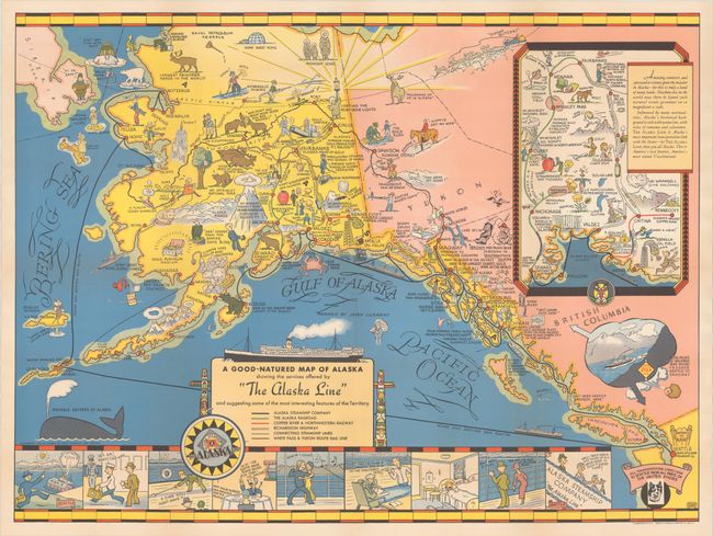
This pictorial tourist map was published by the Alaska Steamship Company to encourage travel from the continental US to Alaska. Steamship routes are shown originating in Seattle, where it is noted that "all transportation lines lead to Seattle from all parts of the United States." Other forms of transportation are identified in Alaska and neighboring Yukon Territory, such as railroads and highways. The map illustrates "some of the most interesting features of the Territory" and popular activities, including Mt. McKinley, active volcanoes, gold dredging, the northern lights, dog sledding, and various types of wildlife depicted as cartoonish rather than dangerous. A large inset in Canada focuses on the region between Anchorage and Fairbanks and includes a note touting Alaska's "natural scenic grandeur" and history "rich with native lore, with tales of romance and adventure." A comic strip at bottom shows how comfortable and luxurious it is to travel via steamship, and a note in British Columbia reassures the seasick traveler of low winds and smooth travel by ship between Seattle and Skagway.
This map was created by Edward Camy (1904-58), a native Californian who spent the majority of his career as a graphic artist in San Francisco. This is the rare first edition, which was reissued in 1939 and 1940 with changes to the steamship routes and coloring.
References: Hornsby (Picturing America) #115; Rumsey #8843.
Condition: A
A bright example issued folding, now flattened and professionally backed in thin, archival tissue.