Subject: Northwestern United States, Canada
Period: 1840 (published)
Publication: A New Universal Atlas
Color: Hand Color
Size:
12.6 x 10.7 inches
32 x 27.2 cm
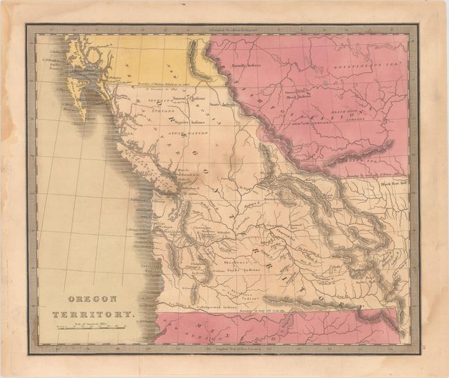
This early map of Oregon Territory was first published by David Burr in 1836. A historical and interesting map, it draws on the explorations of Jedediah Smith, Lewis & Clark, the Hudson Bay Company, and John Jacob Astor's Company for its remarkable degree of information and accuracy. The Oregon Territory extends all the way east to the Rocky Mountains. The northern boundary with the British Possessions is set at 54°40' per the "Boundary of Russian Possessions settled by Convention in 1824." The southern boundary is at 42° per the "treaty with Spain 1819." East of the Rockies, the northern boundary is today's Canadian border and noted as per the "treaty with Gt. Britain 1818." In the south, a remnant of the River of the West theory appears, as the Los Mongos River, that flows to the Pacific from the large L. Timpangos. Information and place names include Friendly Indians, Ft. Clapsop or Ft. George, Edmonton Factory, and more. Jeremiah Greenleaf took over the production of David Burr's New Universal Atlas when Burr was appointed Geographer of the House of Representatives in 1838.
References: Phillips (Maps) p. 642; Phillips (A) #784-48; cf. Wheat (TMW) #402.
Condition: B
Contemporary color with a few stains at center and the bottom right corner impacting the border. Additional dampstains are confined to the blank margins.