Catalog Archive
Auction 182, Lot 199

"Map of Lewis and Clark's, Track Across the Western Portion of North America, from the Mississippi to the Pacific Ocean...", Lewis & Clark

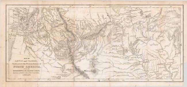
Subject: Western United States

Period: 1842 (circa)

Publication: History of the Expedition...

Color: Black & White

Size:
13.6 x 6 inches
34.5 x 15.2 cm
Download High Resolution Image
(or just click on image to launch the Zoom viewer)

This is a reduced version of the original Lewis & Clark map published in 1814, covering the northern two-thirds of the United States from the Great Lakes to the Pacific Ocean. The route of Lewis and Clark is shown along with details of forts, rivers, mountains and Indian tribes. There are some interesting notes as well, such as "Here the Different Tribes Meet in Friendship & Collect Stone for Pipes." The map was completed by W.G. Evans and revised by Archibald M'Vickar in 1842.

References:

Condition: B

Issued folding with some light foxing and printer's ink residue. There is a small binding trim at bottom right.

Estimate: $220 - $250

Sold for: $120

Closed on 4/28/2021

Archived