Subject: Northern Africa
Period: 1618 (published)
Publication: Theatrum Geographiae Veteris
Color: Hand Color
Size:
18.6 x 12.3 inches
47.2 x 31.2 cm
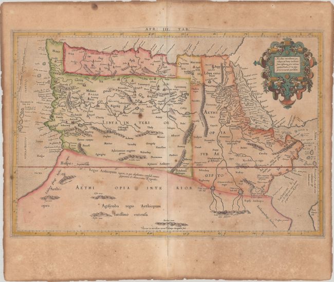
Claudius Ptolemy was a mathematician, astronomer and geographer who worked in Alexandria, then a part of the Roman Empire, in the 2nd century AD. One of the most learned and influential men of his time, his theories dominated both astronomy and geography for nearly 1500 years. His writings were kept alive by Arabic scholars during the Middle Ages and reemerged in Europe during the Renaissance. The birth of printing led to wide dissemination of his great works on astronomy and geography. There were a number of editions of his Geographia beginning in 1477. These early editions contained maps based on his original writings, known as Ptolemaic maps. As geographic knowledge increased with the explorations of Columbus, Magellan, Cabot and others, maps of the New World were added, and maps of the Old World were revised. Ptolemy's Geographia continued to be revised and published by some of the most important cartographers including Martin Waldseemuller, Sebastian Munster, Giacomo Gastaldi, Jodocus Hondius, and Gerard Mercator (whose last edition was published in 1730).
This Ptolemaic map of Northern Africa shows the twin lake sources of the Nile located near the Lune Montes. The Niger River is prominently featured in Libya with its source in several interior lakes, then disappears under several mountain ranges and flows underground. Mercator originally published this map in his 1578 edition of Ptolemy's great Geography. Although Mercator is most renowned today for the projection he popularized and for first using the term Atlas for a collection of maps, he devoted much of his life to his Ptolemaic maps. The maps were beautifully engraved as nearly as possible to their original form and embellished with fine cartouches. This is the first state of this map, with the original cartouche at top right, which was re-engraved in 1695. Latin text on verso with an alternate title: Africae Tabula Quarta, Continens Libyam Interiorem, Aethiopiam quae sub Aegypto est, & Aethiopiam Interiorem. Published by Petrus Bertius, Isaac Elsevier and Jodocus Hondius Jr.
References: Mickwitz & Miekkavaara #232-16; Van der Krogt (Vol. I) #0914:1.1.
Condition: B
There is moderate toning and foxing in the image, as well as heavy toning along the edges of the sheet along with a number of tiny chips along the edges.