Subject: Southern & Southeast Asia
Period: 1600 (dated)
Publication: Geographisch Handtbuch
Color: Hand Color
Size:
11.3 x 7.9 inches
28.7 x 20.1 cm
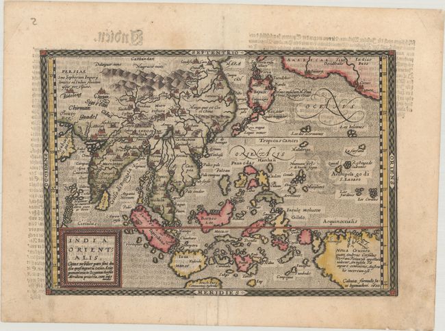
This is based on Abraham Ortelius' map of Southern and Southeast Asia in 1570 and shows very different cartography from Quad's map of Asia, which was based on Gerard de Jode's map. The East Indies are presented as a randomly scattered archipelago with Java and Borneo particularly misshapen. The mythical Chaimai Lacus (here unnamed) is the source of a network of major rivers in Southeast Asia. Beach pars, a presumed promontory of the great southern continent based on Marco Polo's account, protrudes into the bottom of the map. An oversized New Guinea is shown at bottom right and includes a note explaining that Andrea Corsali had identified New Guinea in his explorations, but is was unknown whether it was an island or part of a continent. In the upper right corner, America makes an appearance with the three coastal cities of Quivira, Cicuie, and Tiguex. This map is from a scarce pocket atlas published by Johannes Bussemacher. German text on verso.
References: Mickwitz & Miekkavaara #239-5; Shirley (BL Atlases) T.QUA-2a.
Condition: B+
A dark impression on a sheet with an eagle watermark, light soiling, and a professionally repaired centerfold separation at bottom.