Subject: Western Hemisphere - America
Period: 1796 (dated)
Publication: Atlas der Geographie von der Bekannten Ganzen Welt…
Color: Hand Color
Size:
23.6 x 20.7 inches
59.9 x 52.6 cm
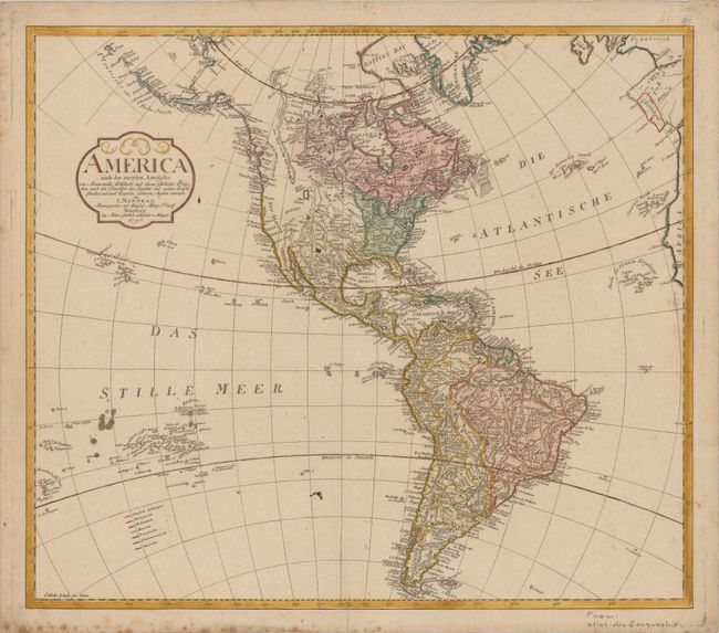
This very uncommon map of the Americas was published by A.G. Schneider and J.A.G. Weigel. The United States appears east of the Mississippi and north of Florida, with notable cities located and Georgia, Carolina, and Kentucke prominently identified. Louisiana and Neu Mexico are shown west of the Mississippi, and Texas, Cenis, and Santa Fe are named. Farther west, Quivira, Teguayo, and Neu Albion appear. The mythical golden city of Teguayo is placed just south of a lake that is likely based on the Great Salt Lake. A second larger lake labeled See is depicted north of this and is probably a late form of the Sea of the West. Alaska is fairly well shaped following the discoveries of Captain Cook, although the western border is only partially delineated. Numerous Pacific islands are shown including the Sandwich Islands. A small Parima See is noted in South America, a remnant of the mythical Lake Parime. Great detail throughout the rest of the map with numerous place and Indian names.
References: Phillips (Atlases) #3527-21.
Condition: B+
A nice impression on a sheet with an "LVI" watermark, several ink stains in the Pacific and one in the Southwest US, and foxing along the bottom edge of the sheet.