Subject: Hong Kong, South China Sea
Period: 1775 (circa)
Publication: Le Neptune Oriental
Color: Black & White
Size:
18.2 x 13.3 inches
46.2 x 33.8 cm
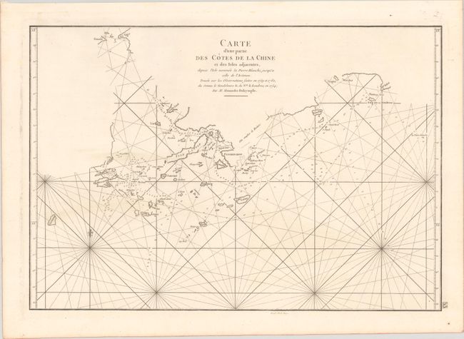
This is the French edition of Alexander Dalrymple's extremely rare A Chart of Part of the Coast of China (1771), which featured the earliest cartographic representation of Hong Kong. The chart centers on present-day Hong Kong, here called Fanchin Chow. It also shows Macao, the mouth of the Pearl River, the Guele du Tigre (Bocca Tigris or Humen), Lantau, Lamma, and several smaller islands. The coastline is not completely rendered, with blank stretches and provisional dotted line borders in Hong Kong. A note northeast of Fanchin Chow describes the rocky coast. The chart is crisscrossed by rhumb lines and filled with soundings. It is based on the surveys made by Dalrymple aboard the Cuddalore in 1759 and 1760 and aboard the London in 1764 (here erroneously written as 1754). Dalrymple was a Scottish hydrographer who explored the East Indies as an employee of the East India Company. This French edition appeared in later editions of Le Neptune Oriental, published by Dalrymple's personal friend Jean B. N. D.Apres de Mannevillette. Engraved by Guillaume Delahaye.
References: cf. Howse & Sanderson XLI; Shirley (BL Atlases) M.APR-1c.
Condition: A
A fine impression on a sturdy watermarked sheet with some marginal soiling.