Subject: Holy Land
Period: 1625 (circa)
Publication:
Color: Hand Color
Size:
19.4 x 11.4 inches
49.3 x 29 cm
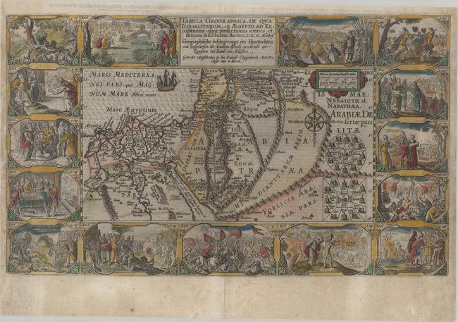
This extremely decorative Bible map illustrates the region surrounding the Dead Sea through the Nile Delta and depicts the wanderings of the Children of Israel. Beautifully engraved panels at the top and bottom include vignettes of important events of Exodus, Deuteronomy and Numbers. Inset within the map are two depictions of the Tribes surrounding the Tabernacle in the desert. This is the second state with improvements by D.R.M. Mathes, published by Cloppenberg. Dutch text on verso.
This is the second series of Dutch bible maps by Petrus Plancius, first published in 1604 by Johannes Cloppenburg. The first series consisted of a world map and 4 small maps of the Holy Land and Middle East, engraved by Johannes van Deutecum and his two sons, Johannes and Baptista. After Johannes van Deutecum (the younger) published a new set of maps in 1595, Plancius realized that his own maps required updating. He commissioned Baptista van Deutecum to engrave the second series, who also enlisted the assistance of engravers Daniel van Bremden and Pieter Bast. Plancius' second series retained the same world map and 6 larger, re-engraved maps of the Holy Land and Middle East. The purpose of the maps was to help explain the biblical texts, but Plancius decided to take the maps one step further by adding 15 biblical vignettes surrounding each map, thereby transforming each map into a work of art.
References: Laor #566; Poortman & Augusteijn #76.
Condition: B
A dark impression on a bright sheet with archival repairs to a centerfold separation at bottom, a short tear at left, and several chips along the left edge of the sheet, with a minor amount of the border replaced in facsimile. The right edge of the sheet has been professionally replaced, with a strip of the border skillfully and seamlessly replaced in facsimile, measuring 3/8" at top and extending to 1" at bottom. The map presents itself beautifully as a result of the excellent facsimile work.