Subject: Western England
Period: 1610 (dated)
Publication: Theatrum Imperii Magnae Britanniae...
Color: Hand Color
Size:
20.3 x 15.1 inches
51.6 x 38.4 cm
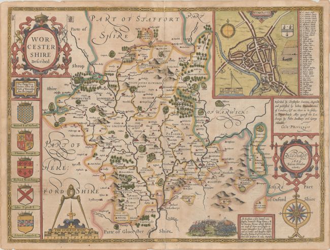
This handsome decorative map of Worcestershire is from John Speed’s groundbreaking English atlas. It divides the county into its hundreds and includes up-to-date detail on towns and cities, parks, forests, hills, rivers, and more. There is an inset town plan of Worcester at top right complete with a compass rose, distance scale, coat of arms featuring 3 Black Worcester pears, and a key identifying 41 sites of interest. The Battle of Evesham (August 1265) is depicted in a vignette at bottom accompanied by a note telling the story of the battle. Below the elaborate title cartouche at left, there are 5 coats of arms representing titled families since the conquest. The composition of this beautiful map is completed by a compass rose and cartouches for the scale of miles and publishers' and engraver's imprints. Engraved by Jodocus Hondius. Published by John Sudbury and George Humble in the Latin edition of 1616.
References: Shirley (BL Atlases) T.SPE-1d.
Condition: B
A nice impression with several edge tears and a long separation along the centerfold that have been closed with archival materials on verso. There is light soiling and toning and minor show-through of manuscript notations on verso.