Subject: Greenland & Canada
Period: 1704 (circa)
Publication: A Collection of Voyages and Travels
Color: Hand Color
Size:
11.1 x 5.2 inches
28.2 x 13.2 cm
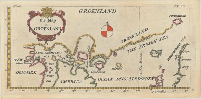
Interesting map showing a continuous coastline from Canada to Spitzberg. The southern tip of Greenland is formed by two large islands with the mythical island of Frisland nearby. This map was included in Volume II of Churchill's Voyages to accompany An Account of Greenland to Monsieur de la Mothe de Vayer by La Peyrere. The map is a copy of La Peyrere's map of 1647. The map was based in part on a map by Jens Munk who led a Danish expedition in search of the Northwest Passage in 1619-20 and was the first to completely map Hudson Bay. La Peyrere made "improvements" to Munk's map, several being incorrect due to his misunderstandings of Munk's commentary. The most important ones being: (1) La Peyrere's map uses parallels and meridians while Munk's map did not; (2) La Peyrere confuses the name Munk gave to Hudson Bay and ends up with two names, King Christians Sea and New Sea instead of New King Christians Sea; (3) La Peyrere shows Baffin Island as several islands while Munk separates only the southern portion; (4) La Peyrere interprets Munk's statement of his progress being stopped at 63° 20' N to mean the location of his winter quarters and therefore moves Hudson Bay a few degrees north; (5) the north coast of Hudson Bay is entirely imaginary, probably borrowed from Best's account of Frobisher's voyage; (6) Greenland is borrowed from Hessel Gerritsz' map.
References: cf. Burden #285.
Condition: A
A sharp impression with a hint of a dampstain at bottom right.