Subject: Peru & Ecuador
Period: 1941 (dated)
Publication:
Color: Printed Color
Size:
25.8 x 18 inches
65.5 x 45.7 cm
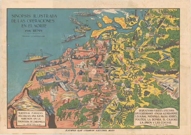
This Peruvian propaganda map was created by Raul Vizcarra during the Ecuadorian–Peruvian War of July 1941 that resulted from border disputes between the two countries. Although there is still today much dispute as to who initiated the conflict, this map clearly depicts Ecuador as the aggressor with Peru defending its border just north of Tumbes. The text explains that the Ecuadorians mobilized their troops and treacherously attacked the Peruvian cities in the north on July 22-23, and that the Peruvian military forces fended off the enemy aggression in the Zarumilla Province. In addition to the battles on land, the map shows the attacks by air and sea, with Peruvian planes bombing Ecuador from above, and Ecuadorian gunboats surrendering to Peruvian battleships just off the coast. Although Ecuador is depicted as heavily armed with a strong military force, the reality of the war was that Ecuador was greatly outnumbered and outgunned by its neighbor, and eventually requested a cease-fire.
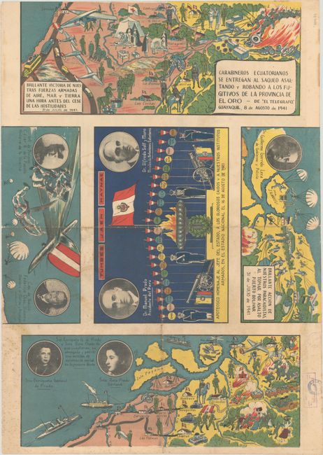
On verso are two additional maps, each split in half with the southern half shown above the northern half, that celebrate the Peruvian victory on July 31 and the "brilliant" actions of the paratroopers and all military personnel involved on land, sea, and by air. The deployment of Peruvian paratroopers during this war was the first such airborne combat operation in South America. Also included on verso are portraits of 7 individuals involved in the war, including the Peruvian President, Dr. Manuel Prado, and his wife and daughter, Enriqueta and Rosa Garland Prado, who were celebrated for their humanitarian efforts during the war.
The term "BEMS" in the title appears to be an acronym created from the initials of the Lima-based Peruvian publishers "Belisario E" and "Mantilla S," who published several maps during the 1940s. This map is extremely rare, and there are no known examples listed in institutions or previous sales records for this map.
References:
Condition: B
Bold color with light soiling, scattered foxing, a few small worm holes, several printer's creases at left, and an old Callao bookseller/library stamp in a corner on verso. The map has been folded and there are a few tiny tears and holes along the folds. A short tear in the right blank margin has been archivally repaired.