Subject: Southwestern United States & Mexico
Period: 1849-63 (dated)
Publication:
Color:
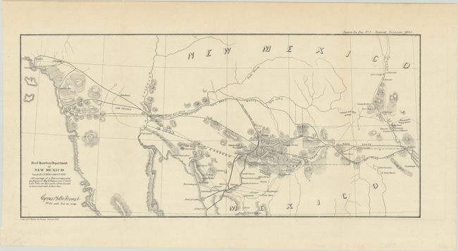
A. Head Quarters Department of New Mexico Santa Fe, N.M. December 25, 1862, by the U.S. War Department, from Sen Ex. Doc. No.1, 37th Congress – Special Session, 1863, dated 1863 (14.3 x 6.6"). This important little map covers the majority of New Mexico Territory and southern California to include Los Angeles and part of Sonora, Mexico. It was drawn by Cyrus H. De Forrest, 1st Lt and Aid-de-camp to Fergusson. The map notes several "Practicable Rail Road" routes across the region and into Mexico. It also locates silver, gold, and copper mines including the Stevensons Silver Mines east of Dona Anna. Several forts are noted including Yuma, Craig, Thorn, and Fillmore. Near today's Puerto Penasco is a Shell Observatory, a location we've not previously seen on any map. Fergusson was charged with making a survey of Port Lobos and Libertad on the Gulf of California to determine whether "Arizona and the Mesilla valley" could be supplied from Kansas City or from Texas. His explorations further demonstrated the viability of a railroad route to the Pacific via a southern route. Wheat considered this the only military map of note produced in 1862 and to which he devotes an entire page of description. Condition: Issued folded. (A)
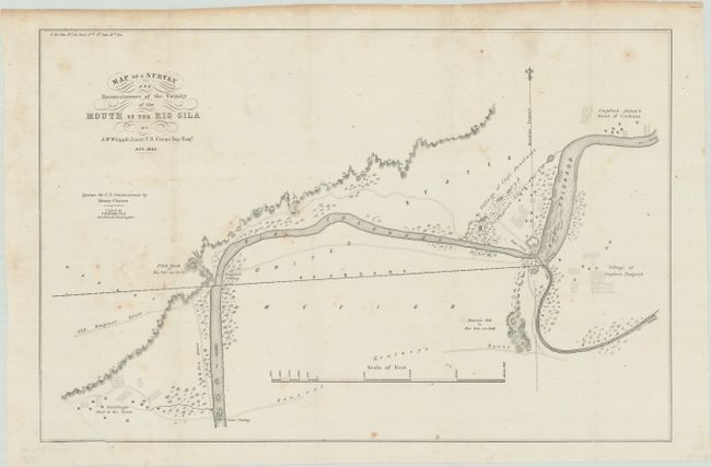
B. Map of a Survey and Reconnaissance of the Vicinity of the Mouth of the Rio Gila, by Amiel Weekes Whipple, from Sen. Ex. Doc. 34, 31st Congress. 1st Session, dated 1849 (16.6 x 10.9"). This map illustrates a critical aspect of the Mexican Boundary Survey (following the Treaty of Guadeloupe Hidalgo) with the determination of an agreed upon point (the middle of the Rio Gila where it enters the Colorado) to anchor the boundary line in the east. The villages of Captain Pasqual, Capt. Anastasio, and Captain Anton in the vicinity of Yuma are noted. It also shows the Old Emigrant Route and General Kearney's Route with notations on three crossings and ferries. This is an important and historical map that is finely engraved with good detail along the rivers. Condition: Folding as issued with light scattered foxing and a binder's crease at bottom left. (B+)
References: Wheat (TMW) #653 & #1042.
Condition:
See description above.