Subject: United States, Mexico & Central America
Period: 1855 (dated)
Publication:
Color: Hand Color
Size:
24.2 x 23.6 inches
61.5 x 59.9 cm
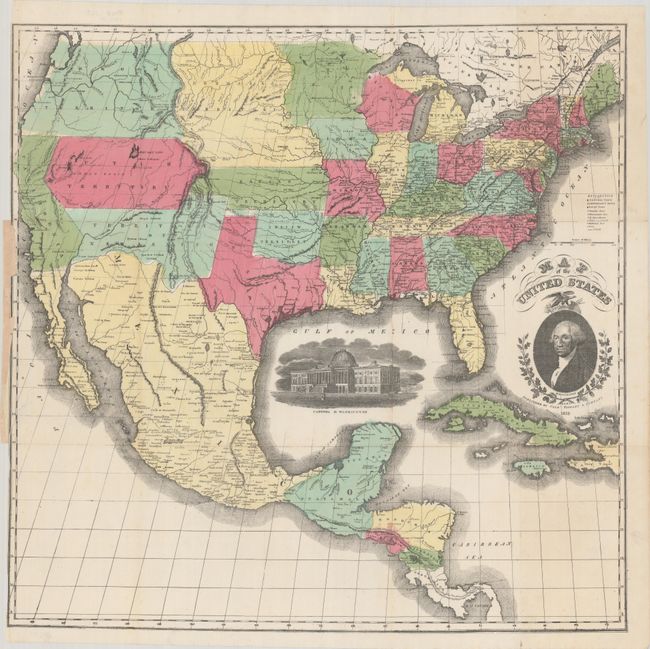
This scarce large-format map of the United States features striking insets of President Washington and a view of the Capitol of Washington. The map's projection oddly distorts and foreshortens the western portion of the U.S. The very interesting territorial configurations include an odd pre-Gadsden Purchase border with Mexico that does a bit of wandering, and a large Oregon Territory that occupies the entire Northwest and extends to the Continental Divide. Oregon is bordered to the east by the huge Missouri Territory that extends to an early configuration of Minnesota Territory at the Missouri River. Indian Territory is correctly shown rather than the huge area occupied in earlier editions of this map. Kansas Territory has just formed between Utah and Missouri with no sign of Colorado. Utah and New Mexico territories are at their largest extent. In Utah a Mormon Settlement is located at the southern end of the Great Salt Lake. The map extends to show Central America to below Panama City into Darien and part of the West Indies to Haiti.
References:
Condition: B+
Issued folding on a clean bright sheet with a 3" edge tear at left that has been closed on verso with archival tape and a few tiny holes in North Carolina that are only visible when held to light.