Subject: Miami Beach, Florida
Period: 1939 (circa)
Publication:
Color: Printed Color
Size:
27 x 15.4 inches
68.6 x 39.1 cm
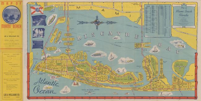
A colorful map of Miami Beach published by the Frank B. Dolph Company. Extends from Fisher Island north to Surfside and shows the street grid pattern, parks, golf courses, pier, clubs, and more. Decorated by an unusual compass rose, numerous boats in Biscayne Bay, state flag, and scroll title cartouche. The verso contains large photographs and a detailed “Business Location Map of Lincoln Road” (4.2 x 23.5"). Self-folding into pictorial wrappers (3.6 x 8.0") and "Compliments of Lee & Williams Co." (which began operation in 1933). Circa date is based upon the hotels shown (all built in the 1930s or earlier) along with the absence of the Grossinger Resort Hotel that was completed in 1940 and remained the tallest building in Miami Beach for the next 30 years. No past sales records or institutional copies located on OCLC.
References:
Condition: A
A clean and colorful example, issued folding, with a few tiny splits at the fold junctions.