Catalog Archive
Auction 181, Lot 228

"Map of the City of Los Angeles Showing Railway Systems",

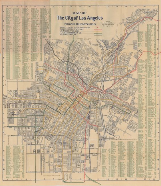
Subject: Los Angeles, California

Period: 1905 (dated)

Publication:

Color: Printed Color

Size:
21.3 x 23.8 inches
54.1 x 60.5 cm
Download High Resolution Image
(or just click on image to launch the Zoom viewer)

A detailed map by the noteworthy Laura Whitlock, one of the few female mapmakers in the United States at the time. The map is centered on downtown and extends to Slauson Avenue in the south, Pico Heights in the west, and Highland Park in the northeast. Color overprinting reveals the numerous rail lines of the Pacific Electric and Los Angeles Railways winding throughout the region. Surrounded by a comprehensive street index. Folds into orange paper wrappers (3.5 x 7.2") with title "Brethren Annual Conference Map of Los Angeles," compliments of Cline-Wall Realty Company. The map was issued to entice conference attendees to visit the Laguna de Teche Grant. The company was offering land with a 25% down payment and, “We can sell you cows on the installment plan, you pay one-half of your monthly milk check until cows are paid for.”

Whitlock's maps were frequently copied on the market, but she was very diligent in litigating to protect her copyright. In fact, one of Whitlock's maps was involved in the first conviction for copyright infringement in the United States. Click herefor a newspaper story from the June 11, 1913 issue of the Los Angeles Herald detailing the conviction.

References:

Condition: B+

On a clean bright sheet with a 3" edge tear at top that has been closed on verso with archival tape. There is a tiny hole in the street index at lower left as a result of a minor paper flaw. Paper wrappers have minor soiling.

Estimate: $220 - $250

Sold for: $230

Closed on 2/10/2021

Archived