Subject: Southwestern United States
Period: 1858 (dated)
Publication: Report upon the Colorado River of the West
Color: Black & White
Size:
34.8 x 14.6 inches
88.4 x 37.1 cm
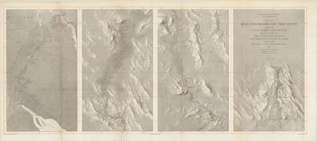
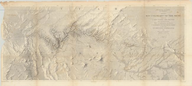
This pair of maps represents one of the most important exploring efforts of the American Southwest. Ives published his explorations in a series of four maps - these being the first two. In his book Mapping of the Trans-Mississippi West, Carl Wheat devotes several pages to these two maps saying they are two of the best created by the remarkable F.W. von Egloffstein. They were engraved using his system that imparts the appearance of depth to the topography and nearly mimics a satellite image. A remarkable accomplishment for the time. The maps were published in 1861. Each map measures the approximate size given.
Map No. 1 shows the topography and geology of the lower Colorado River in four panels (each about 8.5" x 14"), beginning at the Gulf and ending in Black Canyon at Fortification Rock. Locates and names Pt. Invincible, Ogden's Landing, Fort Yuma, Lighthouse Rock, The Needles, the location of Beale's Crossing, Bullshead (today's Bullhead City), Painted Canyon, Fortification Rock, and much more. Numerous rapids are noted including Roaring Rapid 3 large rocks & one sunken rock below, and Violent Rapid with rocks on both sides. Condition: There is some extraneous creasing around some of the folds and a couple short splits at fold intersections. (B+)
Map No. 2 details the region around the Grand Canyon and Little Colorado River. It shows the river from about Needles (Whipple's Crossing and Mojave Canyon) north through Black Canyon, to the Little Colorado and then north to beyond the survey's limit as the riverbed fades to nothing. The map locates Fort Defiance, Campbell's Pass, Zuni, Moquis (Hopi) Pueblos, San Francisco Springs (Flagstaff), Las Vegas, the Mormon Road, numerous Indian tribes, and much more. Several important exploration routes and trails are shown including The Old Spanish Trail, Whipple's trail 1854-4 and Beale's trail. Condition: Along the left edge of the map there are chips with associated loss to the neatline and part of the map image. There are some tears and fold splits, some of which have been closed on verso with archival tape, and light scattered foxing. (C+)
References: Wheat (TMW) #947 & #948.
Condition:
Issued folding. See description above for additional details.