Catalog Archive
Auction 181, Lot 195

The First Comprehensive Map of Northern Texas and Oklahoma

"Topographical Map of the Road from Fort Smith, Arks. to Santa Fe, N.M. and from Dona Ana N.M. to Fort Smith", Marcy, Capt. R.B.

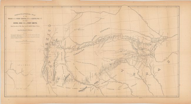
Subject: Southwestern United States

Period: 1850 (published)

Publication:

Color: Black & White

Size:
27.9 x 15.1 inches
70.9 x 38.4 cm
Download High Resolution Image
(or just click on image to launch the Zoom viewer)

This important map delineates, for the first time, the region along the Red and Canadian Rivers. It shows two major roads from Fort Smith to Santa Fe, plus several other routes and Indian trails. The map also notes various tribal lands, topography and hydrology, as well as the location of daily campsites. It is filled with interesting details and notations including the Apache Trail and Comanche Trail - "Said to be a good route for wagons, with water daily." It includes a very early depiction of Dallas located along the Trinity River. Wheat states that "Marcy's was the first comprehensive map of this area."

References: Wheat (TMW) #681.

Condition: B+

Issued folding with light toning and minor foxing. A couple of short edge tears confined to the bottom blank margin have been closed on verso with archival tape.

Estimate: $350 - $425

Sold for: $200

Closed on 2/10/2021

Archived