Subject: Colonial Mid-Atlantic United States
Period: 1777 (dated)
Publication:
Color: Hand Color
Size:
20.5 x 26.3 inches
52.1 x 66.8 cm
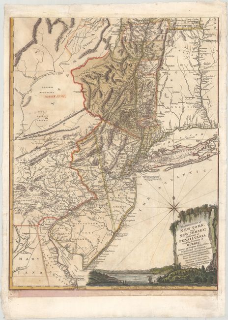
This is the southern sheet of Heinrich Ludwig Broenner's German edition of Thomas Jefferys' two-sheet map based on the surveys of Major Samuel Holland and Governor Thomas Pownall. Holland originally conducted the surveys to settle a boundary dispute between New York and New Jersey and later as Surveyor for the Northern District for the Board of Trade. These surveys provided the British with essential information for the conduct of the military campaigns in the Revolutionary War. German mercenaries, or Hessians, comprised a large segment of British forces in the war resulting in great interest within the German public. This rare edition was published in Frankfurt-am-Main, the largest city in Hesse, home to the majority of these conscripted soldiers.
The map covers the region from Albany, New York to Maryland and Delaware showing the important trade corridor through New York. It includes incredible detail of the individual landowners, roads, forts and mills. The region west of the Delaware River in Pennsylvania is marked Endless Mountains and The Great Swamp, and New Jersey is split into East and West. The pictorial cartouche features a beautiful view of the Hudson River. Engraved by Heinrich Coentgen.
References:
Condition: B+
A crisp impression on a sturdy sheet with a Strasbourg coat of arms watermark, issued folding and now flattened with light toning and soiling, and "Mountains" written in old manuscript ink at top left. There are professional repairs to a hole just above the title cartouche and a small area of paper weakness along the New Jersey shore.