Subject: Sumatra, Bangka Island
Period: 1775 (circa)
Publication: Le Neptune Oriental...
Color: Black & White
Size:
13.2 x 18.9 inches
33.5 x 48 cm
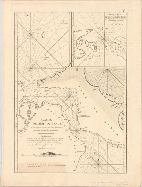
A French sailor and hydrographer, D' Après de Mannevillette (1707-1780) used new instruments to correct the latitudes measured by previous explorers. His atlas Le Neptune Oriental, first published in 1745, was considered a major achievement and an indispensable resource for navigators.
This uncommon sea chart shows the Bangka Strait, separating the southeastern coast of Sumatra from Bangka Island. The handsome chart features detailed navigational information and a small inset at top right. The chart is unusual in that it has been corrected with additional paper superimposed over portions of Bangka Island, showing an updated northern and eastern coastline. A second piece of small paper has been placed in the lower left corner of the chart indicating that these corrections were based upon the observations of Julien Crozet. Crozet led a French expedition to the South Pacific after the voyage's commander, Marion De Fresne, and 26 crew members were killed (and allegedly eaten) by a Maori tribe in the Bay of Islands off the coast of New Zealand.
References: Shirley (BL Atlases) M.APR-1c.
Condition: A
A dark impression on a clean sheet of watermarked paper with a few faint spots. Additional paper has been superimposed on portions of the sheet to show corrections to the chart.