Subject: Holy Land
Period: 1572 (published)
Publication: Theatrum Orbis Terrarum
Color: Hand Color
Size:
18.6 x 13.7 inches
47.2 x 34.8 cm
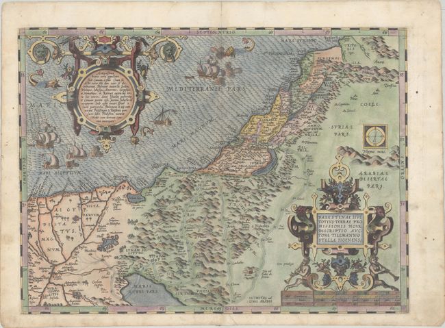
This is Ortelius' first map of the Holy Land. It covers the region from the Nile Delta to Lebanon, and focuses on the desert of the Exodus. Ortelius' map was based on Tilemanno Stella's map of 1557 that became the prototype for the modern cartography of the Holy Land. Stella adapted the coastline and Dead Sea from the configuration of Jacob Ziegler's map of 1532. But here, Ortelius rounds Stella's angular Dead Sea and the Gulf of Aqaba. The map is richly decorated with two elaborate, neoclassical cartouches. The unique square compass rose showing magnetic declination was also copied from Ziegler, but here is curiously shown up-side-down. The sea is teaming with five ships and three sea monsters. This example is from the first of three plates used for the Theatrum, with French text on verso. According to Van den Broecke, this is the third state of this plate with the waves re-engraved more prominently.
References: Nebenzahl (HL) pp. 84-86; Laor #539; Tooley (TMC-3) p. 28; Van den Broecke #170.3.
Condition: A
A crisp impression with gilt highlights on a bright sheet with a bunch of grapes watermark. There is marginal soiling and professional repairs to a centerfold separation at bottom and a couple of short tears in the top blank margin.