Subject: Central England
Period: 1675 (circa)
Publication: Britannia: or the Kingdom of England and Dominion of Wales…
Color: Hand Color
Size:
17.1 x 13.1 inches
43.4 x 33.3 cm
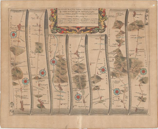
John Ogilby's 'Britannia' was published between 1675 and 1698. It is a landmark in the mapping of England and Wales. Its unique format constituted the first national road-atlas of any country in Western Europe. It was composed of maps of seventy-three major roads and cross-roads, presented in a continuous strip-form, on a uniform scale of one inch to a mile. Each beautiful map includes wonderful detail of the countryside with each strip containing a large compass rose to indicate changes in direction.
Handsome copper engraved road map in the pictorial style as pioneered by Ogilby with the roads laid out in several ribbon-like panels. The map begins in Oakham at milepost 94 and continues in a mostly northerly direction to Milton Mowbray and onward to Abketleby, the Vale of Beaver, Plumtree, Nottingham, Mansfeild, Scardif, Clown, Aughton, Wombwell, and Barnfley. North of Nottingham the Gallowes are located. The area of Robin hood is noted north of Papplewick as "Robin hoods Stone ye Sd. Byrons." Locates via icons and hand coloring churches, fords, bridges, small villages, topography and cross-roads with destination noted. Each of the seven panels has a decorative compass rose to orient the traveler. The title cartouche is in a strapwork and garland style. Plate 48 at bottom right with blank verso.
References:
Condition: B
On a watermarked sheet with moderate toning. There are two small holes in the top blank margin and a short edge tear confined to the left blank margin that has been closed on verso with archival tape.