Subject: Tierra del Fuego & Le Maire Strait
Period: 1785 (circa)
Publication: Relation des Voyages Entrepris par Ordre de sa Majeste Britannique
Color: Black & White
Size:
14 x 11.9 inches
35.6 x 30.2 cm
Captain James Cook (1728-1779) is best known for his three voyages to the Pacific (1768-71; 1772-75; and 1776-79). His discoveries radically changed the western understanding of the world in the late 18th century. He was the first to circumnavigate and chart New Zealand and provided the earliest European accounts of exploration along the eastern coast of Australia and the Hawaiian Islands. On February 14th, 1779, he was killed on Hawaii after attempting to kidnap the chief of the island.
Many contemporary accounts of Cook’s voyages, including charts and engravings, appeared in the late 18th century. The first official account of Cook’s first voyage was published in 1773 by John Hawkesworth in Volumes II and III of An Account of the Voyages Undertaken by the Order of His Present Majesty for Making Discoveries in the Southern Hemisphere... William Strahan and Thomas Cadell published the first official accounts of the second and third voyages in 1777 and 1784. Accounts of his exploration were subsequently translated into French, German, and Dutch.
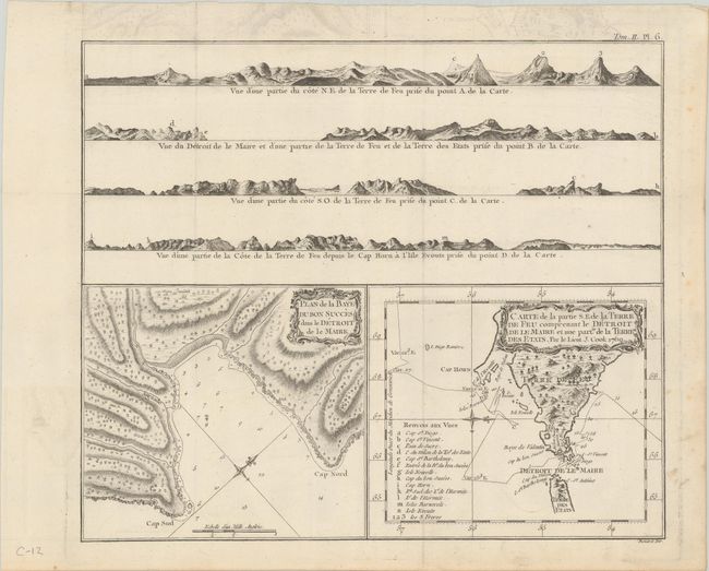
This sheet contains two charts in the lower half beneath four coastal perspectives. The chart of the Le Maire Strait shows the tract of the Endeavor as Captain Cook traveled from east to west between January 11-27, 1769. The chart is oriented with north to the right and includes a lettered key identifying 14 places located on both the map and the land approach views at top. The plan of Success Bay (Baye du Bon Succes) shows great detail including soundings, an anchorage, a compass rose, and a surprising amount of inland detail. Both charts have their own border and decorative rococo-style title cartouche. The four land approach views show portions of the coastline along Tierra del Fuego and Cape Horn from various angles. This early Cook exploration map is from his first voyage, published in a French edition of John Hawkesworth's "An Account of the Voyages Undertaken by the Order of his Present Majesty for Making Discoveries in the Southern Hemisphere." Engraved by Benard.
References: cf. Shirley (BL Atlases) G.HAWK-1a #17.
Condition: B+
A nice impression, issued folding on a watermarked sheet with minor toning, light soiling, and some offsetting in the top blank margin.