Subject: Southwestern United States & Mexico
Period: 1851 (dated)
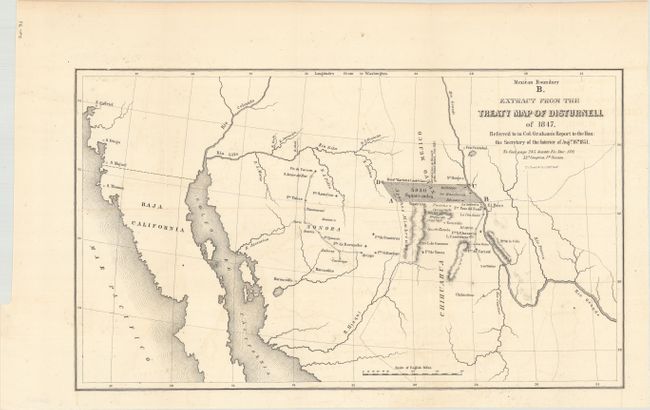
Publication: Sen. Ex. Doc. 119, 32d Congress, 1st Session
Color: Black & White
Size:
15.4 x 8.9 inches
39.1 x 22.6 cm
This map depicts a large shaded region in dispute as a result of a major error in the Disturnell map referenced in the Treaty of Guadalupe Hidalgo. The error was discovered when the American commissioner (John Russell Bartlett) and Mexican commissioner (General Pedro Garcia Conde) began the actual survey work for the southern boundary. Specifically, they discovered that Disturnell's map put the Rio Grande two degrees too far to the west and El Paso was placed about 30 miles too far north. The resulting 5,950 square mile error became a political and economic issue for both sides. The land itself was rich in minerals and, for the United States, was the only practical route for a southern transcontinental railroad. The issue was eventually resolved by the inclusion of the disputed area in the Gadsden Purchase, whereby the United States took over this disputed territory (along with other lands) in exchange for a cash payment.
References: Wheat (TMW) #718; Martin & Martin plt. 40.
Condition: A
Issued folding with a hint of offsetting.