Subject: Texas
Period: 1850 (dated)
Publication: Mitchell’s New Universal Atlas
Color: Hand Color
Size:
15.8 x 12.9 inches
40.1 x 32.8 cm
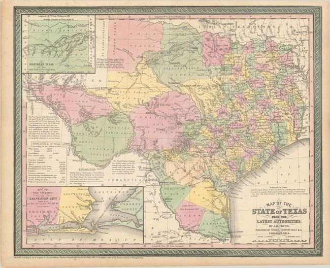
This handsome map of the young state of Texas is one of the most influential atlas maps of the period. The map depicts the new boundaries that were determined by the Compromise of 1850. The organized counties extend only to Cooke in the north and Kinney in the southwest. The western edge of the frontier is marked with a line of army forts separating the settled region from the vast area noted as rolling table lands and desolate plains, Destitute of Timber, that is largely the range of Apache, Kiowa, Comanche, and Lipan Indians. Wagon roads, springs, and trails are identified, including the Apache Trail, Comanche War Trail, Connelly's Trail, and the Emigrant's Route. A dotted line shows the proposed railroad route to the Pacific. Important battlefields in both the Texas war for independence and the Mexican-American War are located. Interesting notations include Grand Indian Crossing, Large Droves of Wild Horses and Cattle, Howard's Spring, Pecos Ferry (on the Pecos River), Horsehead Crossing, etc. Descriptive explanations and notes make this map an interesting study. A table provides statistics according to the Census of 1850 including the population by ethnic groups, e.g. "Free Colored males" is given as 171. There are insets of Northern Texas, noting the northern boundary at Lat. 36° 30', as resolved in the Compromise of 1850, and the vicinity of Galveston City. Dated 1850, but published 1853-54. Engraved by J.L. Hazzard.
References: Day (TX) #35.
Condition: A
A fine impression with contemporary color. There are a couple minor spots in map image.