Catalog Archive
Auction 180, Lot 238

"Map of Palm Springs and Vicinity Showing Points of Interest Accessible via Automobile or Horseback…",

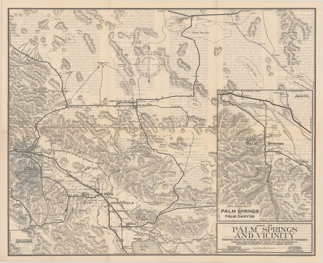
Subject: Palm Springs, California

Period: 1930 (circa)

Publication:

Color: Black & White

Size:
21.4 x 17.3 inches
54.4 x 43.9 cm
Download High Resolution Image
(or just click on image to launch the Zoom viewer)

This detailed highway map coves the area from the Salton Sea north to Palm Springs, Twentynine Palms, and Amboy. It was "compiled for information of guests who are interested in southern California's wonderful desert section." Beyond the road network, the map shows a variety of information including relief, springs, mines, lakes, dry lakes, and more. Includes the large inset "Enlargement of Palm Springs and Palm Canyon" (17 x 21"). Folds into pictorial wrappers (3.8 x 9.0") with "Compliments of the Desert Inn." No past sales records or institutional examples located on OCLC.

According to World War II journalist Ernie Pyle, the founder of the Desert Inn (Nellie Coffman) “started what was to become the whole vast vogue of desert vacationing, all the great resorts – Tucson and Phoenix and Death Valley – the fancy hotels and the southwest dude ranches…it all started with Mother Coffman. The whole thing was built on one woman’s spiritual love of the desert.” For an article on the Desert Inn's history, click here.

References:

Condition: A

A clean example with one short split at a fold junction. Issued folding.

Estimate: $180 - $220

Sold for: $90

Closed on 11/18/2020

Archived