Catalog Archive
Auction 180, Lot 156

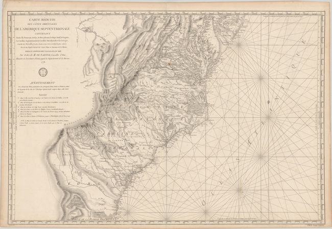
Important Revolutionary War-Era Sea Chart of the Colonial Mid-Atlantic and Southeast

"Carte Reduite des Cotes Orientales de l'Amerique Septentrionale Contenant Partie du Nouveau Jersey, la Pen-sylvanie, le Mary-land, la Virginie, la Caroline Septentrionale, la Caroline Meridionale et la Georgie...", Sartine

Subject: Colonial Mid-Atlantic & Southeast United States

Period: 1778 (dated)

Publication:

Color: Black & White

Size:
34.1 x 23 inches
86.6 x 58.4 cm
Download High Resolution Image
(or just click on image to launch the Zoom viewer)

This large, handsome and important Revolutionary War chart was published by the Depot de la Marine for the French fleet when the focus of the war shifted to the south. The chart extends from Delaware Bay and Philadelphia south through much of Georgia to Amelia Island and St. Johns River. It provides excellent detail along the coast, particularly in the Chesapeake Bay. Surprisingly, it also provides great detail inland to the Appalachians and extends west to Fort Necessity and the Ohio River in Western Virginia. The map shows early county names throughout the region, as well as early roads, Indian tribes, towns, mountains, and rivers. Numerous native tribes are noted and the location of the Catawba Indians Catawbaw Town is shown south of Charlotte. Two Quaker meeting houses are shown east of Salem, NC.

References:

Condition: B+

A dark impression on watermarked paper with a small rust spot adjacent to the upper centerfold. There is faint offsetting and a few minor stains at lower right.

Estimate: $1,300 - $1,600

Sold for: $950

Closed on 11/18/2020

Archived