Subject: United States, World War II
Period: 1941 (circa)
Publication:
Color: Printed Color
Size:
31 x 21.1 inches
78.7 x 53.6 cm
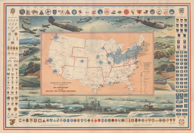
Prior to World War II, pictorial maps portrayed military stations, posts, and operations in a rather formulaic cartoonish, humorous approach. However, as the United States joined the Allied forces in 1941, the cartography took a more serious tone as in the case of the present map.
This thematic map of the continental United States presents the location of both Army and Navy Stations as well as the numerous supporting defense industries including ship yards, planes, guns, munitions, tanks, and more. The map also highlights "industrial areas" in blue, which fully engulfs Indiana, Ohio, and Pennsylvania. Outside of the map image are wonderful illustrations of military aircraft, tanks, and ships. Flanking the left, right, and top are the various insignia of the Army, Navy and Air Force.
References: Hornsby (Picturing America) pp. 225, 230-31.
Condition: B+
Issued folding on a clean sheet with additional folds created by a previous owner. There are several tiny splits at the fold junctions and a 1.5" edge tear that just enters the border at bottom that has been closed on verso with archival tape.