Subject: United States
Period: 1855 (dated)
Publication: Atlas of the World
Color: Hand Color
Size:
26.3 x 15.5 inches
66.8 x 39.4 cm
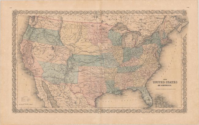
A great map of the United States with early western territorial boundaries. There is no sign of Dakota as Minnesota Territory extends to Nebraska at the Missouri River. The huge Nebraska Territory stretches between Minnesota to Oregon and Washington Territories at the Continental Divide, and south to Kansas. The large Kanzas Territory borders Utah and New Mexico in the west as there is no Colorado. Utah and New Mexico are both shown in their largest configurations. The border with Mexico is post-Gadsden Purchase. The map is filled with details and place names, forts, Indian tribes, emigrant roads, and much more of interest. Several exploration routes are shown, including those of Fremont, Marcy, and Kearney, as well as three proposed routes for the Pacific Railroad. Although it is dated 1855, the map was likely published the following year.
References: Rumsey #0149.016.
Condition: B+
Contemporary color on a lightly toned sheet with an archivally repaired fold separation in the bottom blank margin.