Subject: Atlases
Period: 1824 (published)
Publication:
Color: Hand Color
Size:
10.9 x 14.1 inches
27.7 x 35.8 cm
Finely's maps employ a delicate and elegant engraving style and provided extensive topographical and watershed information. He was the dominant map maker in the United States in the early 1820s into the 1830s. His atlases were very successful, outselling rival atlases by Carey & Lea, and Tanner. His maps were printed on high quality paper and were routinely corrected and updated.
This is the first edition of this important early American atlas, complete with 58 maps and 2 thematic charts. Finley's General Atlas was very popular with the public and went through several editions from 1824-36, outselling rival atlases by Carey & Lea and H.S. Tanner. His maps were printed on high quality paper and employed an elegant engraving style with extensive topographical information that were routinely corrected and updated. Of particular interest in this edition are the maps of the trans-Appalachian west where settlements were rapidly developing on the frontier including:
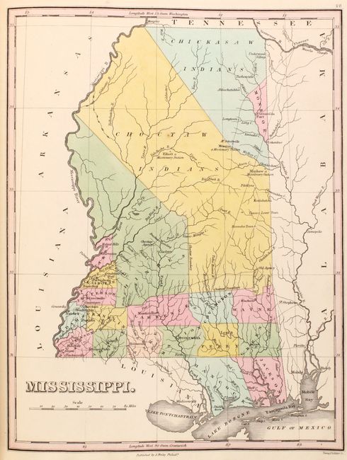
Mississippi. Handsome map of the state that details the county seats, roads, towns and settlements, and watershed. Development is primarily in the southern portion and mostly along the rivers with virtually no other settlements noted. Monroe is the only county in the north, which was carved out of Chickasaw Indian lands where Cotton Gin Port is located. The early U.S. government built a cotton gin here in 1801 as part of a "plan of civilization" for the Chickasaw Indians. The huge Choctaw Indians region occupies the middle section. In it are noted three missionary stations: Mayhew, Elliott and Monroe, plus the Old Agency, and Yazoom Lower Town. The map shows 18 counties, correct for about 1822, plus the Choctaw and Chickasaw Indian areas.
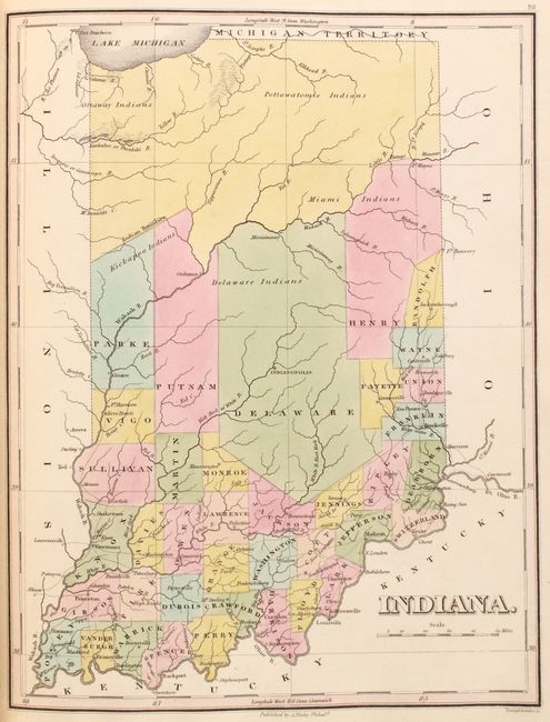
Indiana. Fine early map of the state with only 38 counties. The top third of the state is unorganized beyond the Wabash River and the Indian Boundary with reference to Ottaway, Miami, Delaware, and Pottawatomie Indians. The detailed map shows the roads, towns and settlements with most of the settlements and roads in the lower third of the state.
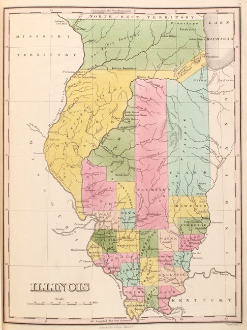
Illinois. The continuation of the Indian Boundary from the above map of Indiana is shown in the upper portion of the state. In this area the tribal lands of the Sac & Fox, and the Winnebago Indians are noted. Below this line, the northern counties are very large with little development although Chicago and Ft. Dearborn are noted. The southern portion of the territory is more developed with a network of roads and trails connecting settlements.
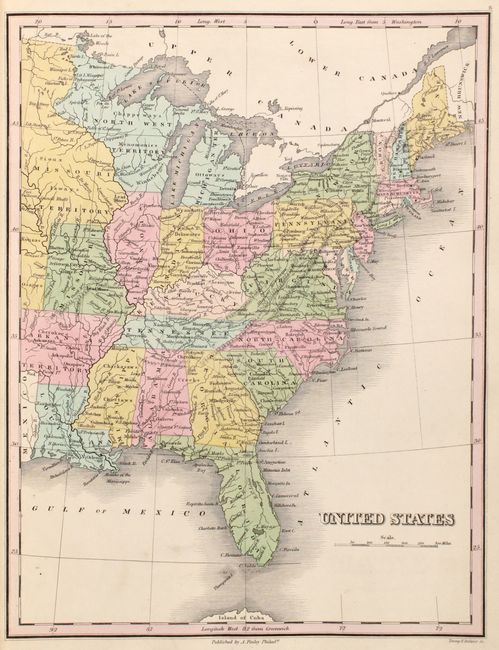
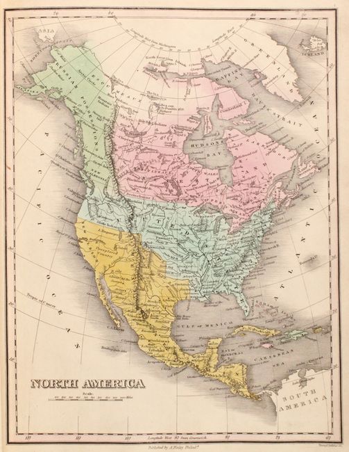
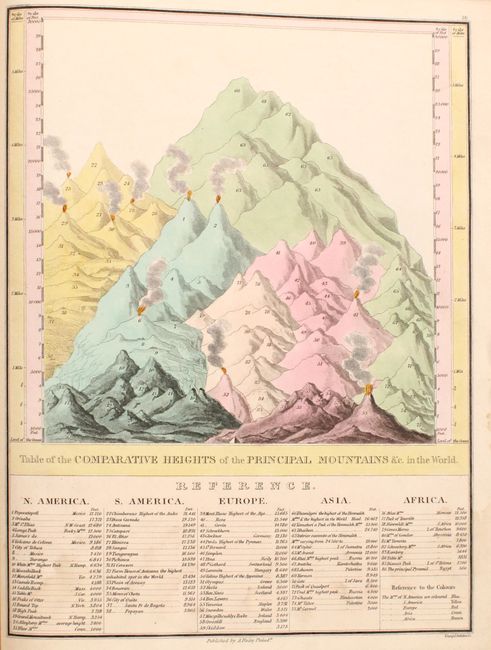
Also of interest is the map of the eastern United States which depict large Missouri, Arkansas, and North West territories. At the back of the atlas are the thematic charts "Comparative eights of the Principal Mountains" and "Comparative Lengths of the Principal Rivers." All maps were engraved by Young & Delleker and the ornate title page and table of contents was lettered by Joseph Perkins. Title page, table of contents, 58 maps, and 2 thematic charts. Rebound in covers from a Dutch atlas, which are blue library buckram with the title (De Wereld in Woord in Kaart in Beeld) in gilt on the front cover and spine. A highly desirable atlas, especially so in the first edition.
References: Phillips (Atlases) #4314; Ristow, pp. 268-270.
Condition:
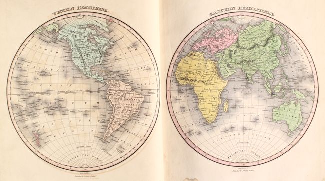
The maps are all in full contemporary color with sharp impressions. The vast majority of the maps are in near fine (A) condition with occasional marginal soiling or damp stains. The maps of the world, western hemisphere and South America and the comparative mountains and rivers charts are in very good (B+) condition with light soiling, offsetting or damp stains in the image. The map of Europe is in good (B) condition with toning and soiling. The map of Scandinavia is in poor condition with heavy toning and a number of tears and holes, and has been backed in paper for support. The title page and list of maps are soiled and chipped along the edges with damp stains at bottom. The atlas has been rebound in the covers of an old Dutch atlas with new endpapers. The edges of the spine are discolored but the covers are otherwise in very good shape.