Subject: Asia
Period: 1642 (circa)
Publication:
Color: Hand Color
Size:
22 x 16.1 inches
55.9 x 40.9 cm
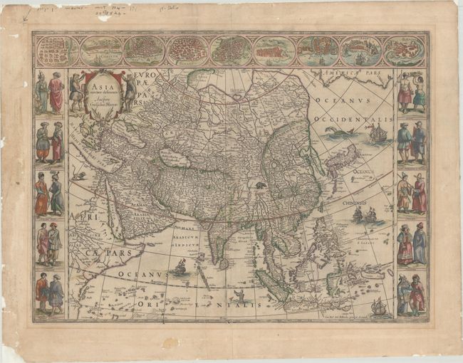
This is one of the most famous 17th century maps of the continent of Asia. It is surrounded by a beautiful carte-a-figures border and is richly ornamented with animals, sea monsters, and sailing ships. The eastern coastline of Asia is severely truncated, Korea is shown as an island, and Japan is depicted on the Ortelius-Teixeira model. The Indian subcontinent is too narrow and the islands of Indonesia are very sketchy. A large island labeled Ceiram probably represents the western part of New Guinea. In the interior, the Caspian Sea is oriented on an east-west axis and there are several large erroneous lakes in China including the mythical Chiamay Lacus. The frieze across the top features vignettes of the cities of Candy, Calecut, Goa, Damascus, Jerusalem, Hormuz, Banten, Aden, and Macao. The inclusion of Banten reflects the emergence of the Dutch as a major commercial power in the East Indies. The side panels flanking the map depict costumed figures of the various Asian peoples. This is a later edition with evidence of a crack in the copperplate at bottom center. Dutch text on verso, published in either Toonneel des Aerdrycks (1642-61) or Grooten Atlas (ca. 1664).
References: Van der Krogt (Vol. II) #8000:2; Walter #25; Yeo #24.
Condition: B
Contemporary outline color in the map with later color in the decorative elements. Backed on archival paper with a number of chips and tears and light toning in the blank margins. There are centerfold separations at top and bottom, with an associated tear at bottom that has been archivally repaired, and light soiling.