Subject: Southern Mexico
Period: 1775 (dated)
Publication: The West Indian Atlas
Color: Hand Color
Size:
24.9 x 18.5 inches
63.2 x 47 cm
Thomas Jefferys was one of the most important English map publishers of the 18th century. His work included prints and maps of locations around the world, but his most notable maps are of North America and the West Indies. He began his career in the map trade in the early 1730s, working as an engraver for a variety of London publishers, and eventually setting up his own shop. In 1746, he was appointed Geographer to the Prince of Wales, and in 1760 he became Geographer to the King. These titles granted access to manuscripts and cartographic information held by the government. In the early 1760s he embarked on an ambitious project to produce a series of English county maps based on new surveys, but ran out of money and filed for bankruptcy in 1766. He then partnered with London publisher Robert Sayer, who reissued many of Jefferys plates and continued to issue new editions after Jefferys' death in 1771. Jefferys' American Atlas and the accompanying West-India Atlas, published post posthumously, are considered his most important cartographic works.
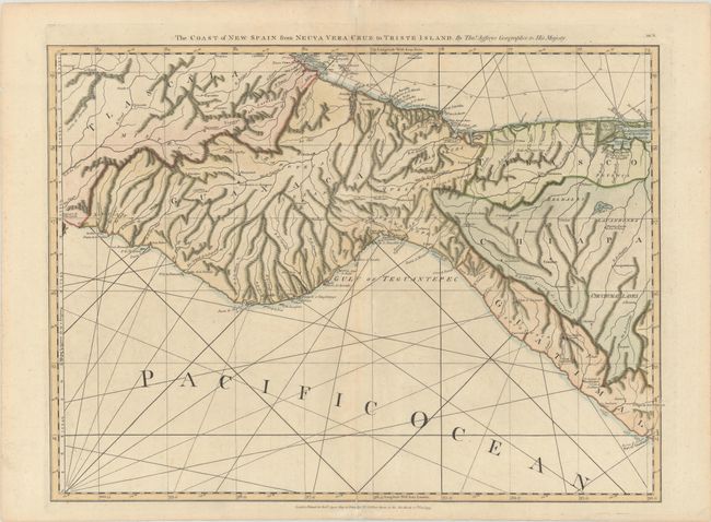
An excellent view of the Isthmus of Tehuantepec showing cities, villages, missions, volcanoes, roads and good topography. The map extends to show part of Guatemala. This is one sheet of the 16-sheet map of the West Indies that formed the heart of this important Revolutionary-period atlas. Sheet number BE.9 printed at upper right. This is the rare first edition with "Nueva" misspelled in the title; it was corrected in later editions. This is one sheet of the sixteen-sheet map of the West Indies that first appeared in the West India Atlas during the Revolutionary War.
References: Shirley (BL Atlases) M.JEF-4a #15.
Condition: B+
A sharp impression on sturdy paper with a large fleur-de-lis coat of arms watermark, very light soiling, a hint of offsetting, and archivally repaired centerfold separations at top and bottom, only entering map border at bottom.