Subject: United States & Mexico, Texas
Period: 1839 (dated)
Publication: Mitchell's School and Family Geography
Color: Hand Color
Size:
16.2 x 10.4 inches
41.1 x 26.4 cm
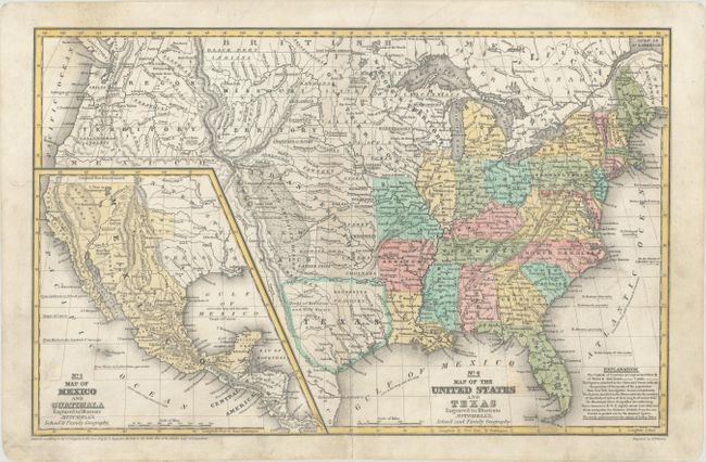
This great school atlas map has early territorial borders in the West and features the Independent Republic of Texas with Austin shown as the capital. The Oregon Territory covers the northwest and extends well into Canada. The huge Indian Territory lies north of Texas and extends to the Missouri Territory, which in turn goes to the Canadian border. Iowa Territory is in a rare configuration, stretching from the state of Missouri to Canada and bounded east and west by the Mississippi and Missouri Rivers. Stretching from the panhandle of Texas up through Indian Territory is the huge Great American Desert. The population is annotated for the states and Texas. The large inset at lower left is a detailed "Map of Mexico and Guatemala" and also shows the Republic of Texas, and details the Spanish holdings in North America.
References:
Condition: B+
Nice impression with professional repairs to a 2.5" edge tear at top and a 3.5" centerfold separation at bottom. Light surface soiling.